
Carte topographique Farlam
Cliquez sur la carte pour afficher l’altitude.
Farlam
Farlam was originally divided into two townships, East Farlam and West Farlam, with a combined population in 1811 of 672 inhabitants and 115 houses. Hallbankgate and Kirkhouse were two hamlets located within the township of East Farlam, the former four miles south east of Brampton, and the latter, where the church stands, half-a-mile east of the village. Milton was a small village in West Farlam and is now in Brampton parish. The whole parish has a high elevation and topographically is quite hilly with an area in 1847 of 5,680 acres.
À propos de cette carte
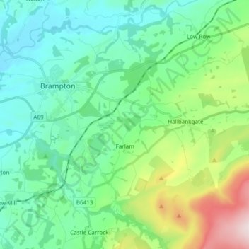
Nom : Carte topographique Farlam, altitude, relief.
Lieu : Farlam, Carlisle, Cumbria, England, United Kingdom (54.90964 -2.71009 54.94788 -2.56018)
Altitude moyenne : 167 m
Altitude minimum : 28 m
Altitude maximum : 611 m
Autres cartes topographiques
Cliquez sur une carte pour visualiser sa topographie, son altitude et son relief.