
Faire un don
Équipez-vous pour votre prochaine aventure :
En tant que Partenaire Amazon, ce site perçoit une commission sur les achats éligibles sans surcoût pour vous.
Carte topographique Carwinley
Cliquez sur la carte pour afficher l’altitude.
Faire un don
Équipez-vous pour votre prochaine aventure :
En tant que Partenaire Amazon, ce site perçoit une commission sur les achats éligibles sans surcoût pour vous.
À propos de cette carte
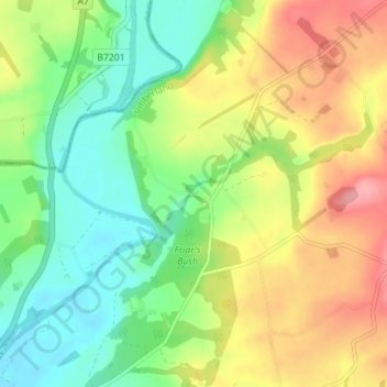
Nom : Carte topographique Carwinley, altitude, relief.
Altitude moyenne : 57 m
Altitude minimum : 15 m
Altitude maximum : 113 m
Faire un don
Équipez-vous pour votre prochaine aventure :
En tant que Partenaire Amazon, ce site perçoit une commission sur les achats éligibles sans surcoût pour vous.
Autres cartes topographiques
Cliquez sur une carte pour visualiser sa topographie, son altitude et son relief.
Farlam
United Kingdom > England > Cumbria > Carlisle
Farlam was originally divided into two townships, East Farlam and West Farlam, with a combined population in 1811 of 672 inhabitants and 115 houses. Hallbankgate and Kirkhouse were two hamlets located within the township of East Farlam, the former four miles south east of Brampton, and the latter, where the…
Altitude moyenne : 167 m
Faire un don
Équipez-vous pour votre prochaine aventure :
En tant que Partenaire Amazon, ce site perçoit une commission sur les achats éligibles sans surcoût pour vous.