
Carte topographique Washington County
Carte interactive
Cliquez sur la carte pour afficher l’altitude.
À propos de cette carte
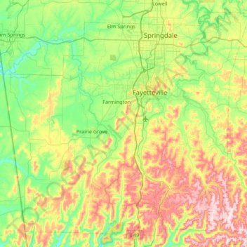
Nom : Carte topographique Washington County, altitude, relief.
Lieu : Washington County, Arkansas, United States (35.75031 -94.55217 36.23824 -93.88827)
Altitude moyenne : 424 m
Altitude minimum : 272 m
Altitude maximum : 738 m
The economy of Washington County was based on apples in the late 19th century. A mixture of wet weather, altitude, and loamy soils provided a good environment for apple orchards. First planted in areas around Lincoln, Evansville, and Cane Hill in the 1830s, apple orchards began all across the county. The United States Census reported a crop of 614,924 bushels of apples produced by the county in 1900, the highest in the state. Several varieties of apple were discovered in the area including Shannon Pippin, Wilson June, and most notably the Arkansas Black. The Ben Davis became the apple of choice in the area for sale and shipment across the region. Corn became the dominant crop, outselling apples by almost $500,000 in 1900.
Autres cartes topographiques
Cliquez sur une carte pour visualiser sa topographie, son altitude et son relief.
Black Oak
United States > Arkansas > Washington County
Black Oak, Washington County, Arkansas, United States
Altitude moyenne : 427 m
Coulter Lake
United States > Arkansas > Pulaski County > Little Rock
Coulter Lake, Little Rock, Pulaski County, Arkansas, United States
Altitude moyenne : 100 m
Sherwood
United States > Arkansas > Pulaski County
Sherwood, Pulaski County, Arkansas, 72120, United States
Altitude moyenne : 108 m
McNeil
United States > Arkansas > Columbia County
McNeil, Columbia County, Arkansas, United States
Altitude moyenne : 105 m
Horseshoe Bend
United States > Arkansas > Izard County
Horseshoe Bend, Izard County, Arkansas, 72512, United States
Altitude moyenne : 216 m
Saint Claire
United States > Arkansas > Crittenden County
Saint Claire, Crittenden County, Arkansas, United States
Altitude moyenne : 66 m
Pine Bluff
United States > Arkansas > Jefferson County
Pine Bluff, Jefferson County, Arkansas, United States
Altitude moyenne : 69 m
Drasco
United States > Arkansas > Cleburne County
Drasco, Cleburne County, Arkansas, 72530, United States
Altitude moyenne : 309 m
Garland County
Garland County, Arkansas, United States
Altitude moyenne : 224 m
Hot Spring County
Hot Spring County, Arkansas, United States
Altitude moyenne : 126 m
Mount Ida
United States > Arkansas > Montgomery County
Mount Ida, Montgomery County, Arkansas, United States
Altitude moyenne : 215 m
Norfork
United States > Arkansas > Baxter County
Norfork, Baxter County, Arkansas, 72658, United States
Altitude moyenne : 183 m
Ben Lomond
United States > Arkansas > Sevier County
Ben Lomond, Sevier County, Arkansas, 71823, United States
Altitude moyenne : 117 m
Cooper Point
United States > Arkansas > Stone County
Cooper Point, Stone County, Arkansas, 72560, United States
Altitude moyenne : 303 m
Brookland
United States > Arkansas > Craighead County
Brookland, Craighead County, Arkansas, 72417, United States
Altitude moyenne : 83 m
North Little Rock
United States > Arkansas > Pulaski County
North Little Rock, Pulaski County, Arkansas, United States
Altitude moyenne : 96 m
Rose City
United States > Arkansas > Pulaski County > North Little Rock
Rose City, North Little Rock, Pulaski County, Arkansas, 72117, United States
Altitude moyenne : 76 m
Wallaceburg
United States > Arkansas > Hempstead County
Wallaceburg, Hempstead County, Arkansas, 71825, United States
Altitude moyenne : 108 m
Huntsville
United States > Arkansas > Madison County
Huntsville, Madison County, Arkansas, United States
Altitude moyenne : 442 m
El Dorado
United States > Arkansas > Union County
El Dorado, Union County, Arkansas, United States
Altitude moyenne : 66 m
Maumelle
United States > Arkansas > Pulaski County
Maumelle, Pulaski County, Arkansas, 72113, United States
Altitude moyenne : 87 m
Lakeview
United States > Arkansas > Baxter County
Lakeview, Baxter County, Arkansas, 72642, United States
Altitude moyenne : 222 m
Mount Magazine State Park
United States > Arkansas > Logan County
Mount Magazine State Park, Signal Hill Trail, Logan County, Arkansas, United States
Altitude moyenne : 667 m
Parkdale
United States > Arkansas > Ashley County
Parkdale, Ashley County, Arkansas, United States
Altitude moyenne : 36 m
Jefferson County
Jefferson County, Arkansas, United States
Altitude moyenne : 68 m
Decatur
United States > Arkansas > Benton County
Decatur, Benton County, Arkansas, 72722, United States
Altitude moyenne : 379 m
Greers Ferry
United States > Arkansas > Cleburne County
Greers Ferry, Cleburne County, Arkansas, 72067, United States
Altitude moyenne : 162 m
Thorn Crown Chapel
United States > Arkansas > Carroll County > Eureka Springs
Thorn Crown Chapel, US 62, Eureka Springs, Carroll County, Arkansas, 72631, United States
Altitude moyenne : 390 m
Wilmot
United States > Arkansas > Ashley County
Wilmot, Ashley County, Arkansas, United States
Altitude moyenne : 36 m
Willow Beach Lake Dam
United States > Arkansas > Pulaski County > North Little Rock
Willow Beach Lake Dam, North Little Rock, Pulaski County, Arkansas, 72142, United States
Altitude moyenne : 73 m
Yates Mountain
United States > Arkansas > Madison County
Yates Mountain, Madison County, Arkansas, 72742, United States
Altitude moyenne : 476 m
Egypt
United States > Arkansas > Craighead County
Egypt, Craighead County, Arkansas, 72427, United States
Altitude moyenne : 76 m
Eudora
United States > Arkansas > Chicot County
Eudora, Chicot County, Arkansas, 71640, United States
Altitude moyenne : 37 m
Carroll County
Carroll County, Arkansas, United States
Altitude moyenne : 423 m
Dagmar
United States > Arkansas > Monroe County
Dagmar, Monroe County, Arkansas, United States
Altitude moyenne : 52 m
Cherry Valley
United States > Arkansas > Cross County
Cherry Valley, Cross County, Arkansas, United States
Altitude moyenne : 87 m
Malvern
United States > Arkansas > Hot Spring County > Malvern
Malvern, Hot Spring County, Arkansas, 72104, United States
Altitude moyenne : 101 m
Fort Smith
United States > Arkansas > Sebastian County
Fort Smith, Sebastian County, Arkansas, United States
Altitude moyenne : 140 m
Horseshoe Lake
United States > Arkansas > Crittenden County
Horseshoe Lake, Crittenden County, Arkansas, 72348, United States
Altitude moyenne : 62 m
Fountain Lake
United States > Arkansas > Garland County > Fountain Lake
Fountain Lake, Garland County, Arkansas, 71901, United States
Altitude moyenne : 165 m
Beaver Lake
United States > Arkansas > Benton County > Goshen
Beaver Lake, Goshen, Benton County, Arkansas, 72757, United States
Altitude moyenne : 394 m
Stone County
United States > Arkansas > Stone County
Stone County, Arkansas, United States
Altitude moyenne : 268 m
Maumelle
United States > Arkansas > Pulaski County > Maumelle > Maumelle
Maumelle, Pulaski County, Arkansas, 72113, United States
Altitude moyenne : 88 m
Starkey Hill
United States > Arkansas > White County
Starkey Hill, White County, Arkansas, United States
Altitude moyenne : 215 m
Coler Creek
United States > Arkansas > Benton County > Bentonville
Coler Creek, Bentonville, Benton County, Arkansas, 72716, United States
Altitude moyenne : 371 m
White County
United States > Arkansas > White County
White County, Arkansas, United States
Altitude moyenne : 111 m