
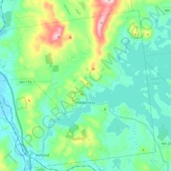
Carte topographique Holderness
Carte interactive
Cliquez sur la carte pour afficher l’altitude.
À propos de cette carte
Nom : Carte topographique Holderness, altitude, relief.
Altitude moyenne : 252 m
Altitude minimum : 138 m
Altitude maximum : 657 m
According to the United States Census Bureau, the town has a total area of 35.7 square miles (92.5 km2), of which 30.3 square miles (78.6 km2) are land and 5.4 square miles (13.9 km2) are water, comprising 15.05% of the town.[1] Bounded on the northwest by the Pemigewasset River, Holderness is drained by Owl Brook and the Squam River. Part of Squam Lake is in the east, and Little Squam Lake is in the center. Mount Prospect, with an elevation of 2,064 feet (629 m) above sea level, is in the north. The highest point in Holderness is Mount Webster in the northeast part of the town, elevation 2,076 feet (633 m) and part of the Squam Range. Via the Pemigewasset River, Holderness lies fully within the Merrimack River watershed.[7]
Autres cartes topographiques
Cliquez sur une carte pour visualiser sa topographie, son altitude et son relief.
Lyman
United States > New Hampshire > Grafton County
Lyman, Grafton County, New Hampshire, United States
Altitude moyenne : 347 m
Warren
United States > New Hampshire > Grafton County
Warren, Grafton County, New Hampshire, United States
Altitude moyenne : 475 m
Bonsai
United States > New Hampshire > Grafton County > Rumney
Bonsai, Rumney, Grafton County, New Hampshire, 03266, United States
Altitude moyenne : 246 m
Franconia
United States > New Hampshire > Grafton County
Franconia, Grafton County, New Hampshire, 03580, United States
Altitude moyenne : 558 m
Waterville Valley
United States > New Hampshire > Grafton County
Waterville Valley, Grafton County, New Hampshire, 03215, United States
Altitude moyenne : 649 m
Groton
United States > New Hampshire > Grafton County
Groton, Grafton County, New Hampshire, United States
Altitude moyenne : 366 m
Plymouth
United States > New Hampshire > Grafton County
Plymouth, Grafton County, New Hampshire, 03264, United States
Altitude moyenne : 264 m
Wentworth
United States > New Hampshire > Grafton County
Wentworth, Grafton County, New Hampshire, 03282, United States
Altitude moyenne : 422 m
Bath
United States > New Hampshire > Grafton County
Bath, Grafton County, New Hampshire, 03740, United States
Altitude moyenne : 289 m
North Haverhill
United States > New Hampshire > Grafton County > Haverhill
North Haverhill, Haverhill, Grafton County, New Hampshire, 03774, United States
Altitude moyenne : 149 m
Stinson Lake
United States > New Hampshire > Grafton County > Rumney > Stinson Lake
Stinson Lake, Rumney, Grafton County, New Hampshire, United States
Altitude moyenne : 460 m
Echo Lake
United States > New Hampshire > Grafton County > Franconia
Echo Lake, Franconia, Grafton County, New Hampshire, United States
Altitude moyenne : 693 m
Lebanon
United States > New Hampshire > Grafton County
Lebanon, Grafton County, New Hampshire, United States
Altitude moyenne : 274 m
Mount Kineo, East Peak
United States > New Hampshire > Grafton County > Ellsworth
Mount Kineo, East Peak, Ellsworth, Grafton County, New Hampshire, United States
Altitude moyenne : 710 m
Etna
United States > New Hampshire > Grafton County > Hanover
Etna, Hanover, Grafton County, New Hampshire, 03750, United States
Altitude moyenne : 296 m
Bristol
United States > New Hampshire > Grafton County
Bristol, Grafton County, New Hampshire, 03222, United States
Altitude moyenne : 254 m
Enfield
United States > New Hampshire > Grafton County
Enfield, Grafton County, New Hampshire, United States
Altitude moyenne : 366 m
Sugar Hill
United States > New Hampshire > Grafton County > Sugar Hill
Sugar Hill, Grafton County, New Hampshire, 03586, United States
Altitude moyenne : 372 m
Mount Agassiz
United States > New Hampshire > Grafton County > Bethlehem
Mount Agassiz, Bethlehem, Grafton County, New Hampshire, 03574, United States
Altitude moyenne : 558 m
Littleton
United States > New Hampshire > Grafton County > Littleton
Littleton, Grafton County, New Hampshire, United States
Altitude moyenne : 360 m
North Littleton
United States > New Hampshire > Grafton County > Littleton > North Littleton
North Littleton, Littleton, Grafton County, New Hampshire, United States
Altitude moyenne : 333 m
West Lebanon
United States > New Hampshire > Grafton County > Lebanon > West Lebanon
West Lebanon, Lebanon, Grafton County, New Hampshire, 03784, United States
Altitude moyenne : 165 m
Lebanon
United States > New Hampshire > Grafton County > Lebanon
Lebanon, Grafton County, New Hampshire, 03766-1355, United States
Altitude moyenne : 315 m
LeBruns Mobile Home Park
United States > New Hampshire > Grafton County > Lebanon > LeBruns Mobile Home Park
LeBruns Mobile Home Park, Lebanon, Grafton County, New Hampshire, United States
Altitude moyenne : 326 m
Thornton
United States > New Hampshire > Grafton County
Thornton, Grafton County, New Hampshire, United States
Altitude moyenne : 474 m
Bethlehem
United States > New Hampshire > Grafton County > Bethlehem
Bethlehem, Grafton County, New Hampshire, 03574, United States
Altitude moyenne : 528 m
Easton
United States > New Hampshire > Grafton County
Easton, Grafton County, New Hampshire, United States
Altitude moyenne : 586 m
Lincoln
United States > New Hampshire > Grafton County
Lincoln, Grafton County, New Hampshire, 03251, United States
Altitude moyenne : 677 m
Lyme
United States > New Hampshire > Grafton County
Lyme, Grafton County, New Hampshire, United States
Altitude moyenne : 297 m
Orford
United States > New Hampshire > Grafton County
Orford, Grafton County, New Hampshire, United States
Altitude moyenne : 300 m