
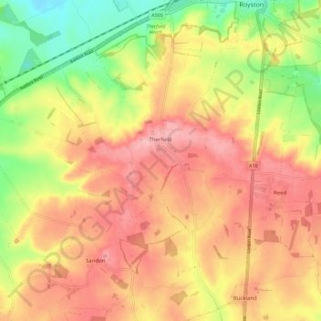
Carte topographique Therfield
Carte interactive
Cliquez sur la carte pour afficher l’altitude.
À propos de cette carte
Nom : Carte topographique Therfield, altitude, relief.
Altitude moyenne : 122 m
Altitude minimum : 51 m
Altitude maximum : 172 m
Autres cartes topographiques
Cliquez sur une carte pour visualiser sa topographie, son altitude et son relief.
St Paul's Walden
United Kingdom > England > Hertfordshire > North Hertfordshire
St Paul's Walden, North Hertfordshire, Hertfordshire, England, United Kingdom
Altitude moyenne : 121 m
Hitchin
United Kingdom > England > Hertfordshire > North Hertfordshire
Hitchin, North Hertfordshire, Hertfordshire, England, SG5 1BB, United Kingdom
Altitude moyenne : 91 m
Barley
United Kingdom > England > Hertfordshire > North Hertfordshire
Barley, North Hertfordshire, Hertfordshire, England, United Kingdom
Altitude moyenne : 103 m