
Carte topographique Moho Tani
Carte interactive
Cliquez sur la carte pour afficher l’altitude.
À propos de cette carte
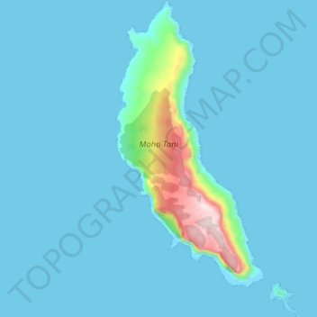
Nom : Carte topographique Moho Tani, altitude, relief.
Altitude moyenne : 41 m
Altitude minimum : -5 m
Altitude maximum : 516 m
It is a high island, with its highest elevation (520 meters) in the south, and its overall shape resembles the back of a whale.
Autres cartes topographiques
Cliquez sur une carte pour visualiser sa topographie, son altitude et son relief.
Fatu Huku
France > French Polynesia > Marquesas Islands > Hiva Oa
Fatu Huku, Puamau, Hiva Oa, Marquesas Islands, French Polynesia, France
Altitude moyenne : 8 m