
Carte topographique Fatu Huku
Carte interactive
Cliquez sur la carte pour afficher l’altitude.
Fatu Huku
The island is essentially a huge rock, looming steep-sided out of the ocean and rising to a flattened plateau with a maximum elevation of 361 metres (1,184 ft). Fatu Huku is the youngest of the volcanic Marquesas Islands, estimated to be only 1.3 million years old which accounts, in part, for its ruggedness as erosion has not yet carved out valleys and beaches. Coral is rare in the Marquesas, but a fossilized ancient coral reef is found at the higher elevations of Fatu Huku. The island is also surrounded by a roughly triangular-shaped barrier reef that is completely submerged, but can faintly be seen on satellite images.
À propos de cette carte
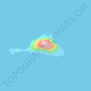
Nom : Carte topographique Fatu Huku, altitude, relief.
Altitude moyenne : 8 m
Altitude minimum : -12 m
Altitude maximum : 342 m
Autres cartes topographiques
Cliquez sur une carte pour visualiser sa topographie, son altitude et son relief.
Moho Tani
France > French Polynesia > Marquesas Islands > Hiva Oa
It is a high island, with its highest elevation (520 meters) in the south, and its overall shape resembles the back of a whale.
Altitude moyenne : 41 m