
Carte topographique Bara
Carte interactive
Cliquez sur la carte pour afficher l’altitude.
À propos de cette carte
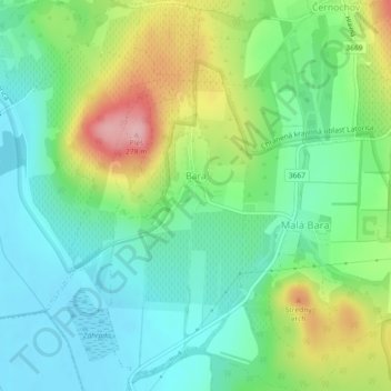
Nom : Carte topographique Bara, altitude, relief.
Altitude moyenne : 160 m
Altitude minimum : 108 m
Altitude maximum : 267 m
The village lies at an altitude of 181 metres and covers an area of 6.252 km². It has a population of 350 people.
Autres cartes topographiques
Cliquez sur une carte pour visualiser sa topographie, son altitude et son relief.
Bačka
Slovakia > Region of Košice > District of Trebišov
Bačka, District of Trebišov, Region of Košice, Eastern Slovakia, Slovakia
Altitude moyenne : 101 m
Streda nad Bodrogom
Slovakia > Region of Košice > District of Trebišov
Streda nad Bodrogom, District of Trebišov, Region of Košice, Eastern Slovakia, 076 31, Slovakia
Altitude moyenne : 106 m
Boťany
Slovakia > Region of Košice > District of Trebišov
Boťany, District of Trebišov, Region of Košice, Eastern Slovakia, 076 43, Slovakia
Altitude moyenne : 101 m