
Carte topographique Morang
Carte interactive
Cliquez sur la carte pour afficher l’altitude.
Morang
Morang District (Nepali: मोरङ जिल्ला listen) is located in Koshi Province in eastern Nepal. It is an Outer Terai district. It borders Jhapa to the east, Dhankuta and Panchthar to the north, Sunsari to the west, and Bihar, India, to the south. Morang has one metropolitan city (Biratnagar), eight municipalities and eight rural municipalities. The total area of Morang is 1,855 km2 (716 sq mi). The lowest elevation point is 60 meters and the highest is 2410 meters above sea level. The headquarters of Morang is connected by the Koshi National Highway to the east–west Mahendra National Highway at Itahari, Sunsari, and Morang is also connected to the Hill parts of the eastern region of Nepal. Morang is the core industrial sector for the eastern region of Nepal.
À propos de cette carte
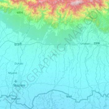
Nom : Carte topographique Morang, altitude, relief.
Lieu : Morang, Koshi Province, Nepal (26.34776 87.23847 26.87340 87.69077)
Altitude moyenne : 262 m
Altitude minimum : 58 m
Altitude maximum : 2 340 m
Autres cartes topographiques
Cliquez sur une carte pour visualiser sa topographie, son altitude et son relief.
Lhotse
Nepal > Koshi Province > Solukhumbu
Lhotse (Nepali: ल्होत्से, romanized: L'hōtsē [lotse]; Standard Tibetan: ལྷོ་རྩེ, romanized: lho tse, lit. 'South Peak' [l̥otse]; Chinese: 洛子峰) is the fourth-highest mountain on Earth, after Mount Everest, K2, and Kangchenjunga. At an elevation of 8,516 metres (27,940…
Altitude moyenne : 7 391 m
Gokyo
Nepal > Koshi Province > Solukhumbu
The village is located at an elevation of 4,750 m (15,584 ft), making it one of the highest settlements in Nepal and in the world. Almost all the buildings are guest houses for trekkers. The people who live in the village leave during the winter and move to other (lower) villages such as Namche Bazaar.
Altitude moyenne : 4 919 m
Ilam
Nepal > Koshi Province > Ilam
The word ‘Ilam’ comprises two words-‘I’ and ‘Lam’. In Limbu language, the word ‘I’ means ‘winding’ and ‘lam’ denotes the way. The topography of this Ilam aptly depicts several winding paths crisscrossing.
Altitude moyenne : 919 m
Phaplu
Nepal > Koshi Province > Solukhumbu
Phaphlu is a mountainous town in north-east Nepal, approximately 270 kilometres east of the Nepalese capital, Kathmandu. The altitude of the village is 2,413 m.
Altitude moyenne : 2 518 m
Lukla
Nepal > Koshi Province > Solukhumbu
Lukla village holds a small airport serving the region, and a variety of shops and lodges catering to tourists and trekkers, providing western-style meals and trail supplies. From Lukla, travelers need two days to reach the village of Namche Bazaar, an altitude-acclimatization stop for those continuing on. The…
Altitude moyenne : 2 996 m