
Carte topographique Conservation Area
Cliquez sur la carte pour afficher l’altitude.
À propos de cette carte
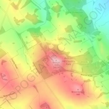
Nom : Carte topographique Conservation Area, altitude, relief.
Altitude moyenne : 168 m
Altitude minimum : 75 m
Altitude maximum : 247 m
Autres cartes topographiques
Cliquez sur une carte pour visualiser sa topographie, son altitude et son relief.
South Croxton
United Kingdom > England > Leicestershire > Charnwood > South Croxton
The highest point is the church, at 120 m above mean sea level. The lowest altitude is 85 m by the Queniborough Brook.
Altitude moyenne : 108 m
Queniborough
United Kingdom > England > Leicestershire > Charnwood > Queniborough
Altitude moyenne : 75 m
Beeby
United Kingdom > England > Leicestershire > Charnwood
The physical and historical development of the hamlet has been strongly influenced by the local topography and its relative isolation. Beeby is situated within an established agricultural landscape largely in pastoral use. Until 1904 the east-west route was the only route through the hamlet, which was referred…
Altitude moyenne : 101 m
Barrow upon Soar
United Kingdom > England > Leicestershire > Charnwood > Barrow upon Soar
Altitude moyenne : 62 m
Mountsorrel
United Kingdom > England > Leicestershire > Charnwood > Mountsorrel
Altitude moyenne : 57 m
Charnwood Water
United Kingdom > England > Leicestershire > Charnwood > Woodthorpe
Altitude moyenne : 47 m
Old John
United Kingdom > England > Leicestershire > Charnwood > Newtown Linford
Altitude moyenne : 143 m
Six Hills
United Kingdom > England > Leicestershire > Charnwood > Burton on the Wolds
Altitude moyenne : 128 m
East Goscote
United Kingdom > England > Leicestershire > Charnwood > East Goscote
Altitude moyenne : 61 m
Barrow upon Soar
United Kingdom > England > Leicestershire > Charnwood > Barrow upon Soar
Altitude moyenne : 62 m
Mammoth Lake
United Kingdom > England > Leicestershire > Charnwood > Thurmaston
Altitude moyenne : 58 m