Carte topographique Beeby
Carte interactive
Cliquez sur la carte pour afficher l’altitude.
À propos de cette carte
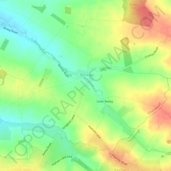
Nom : Carte topographique Beeby, altitude, relief.
Lieu : Beeby, Charnwood, Leicestershire, England, United Kingdom (52.65503 -1.04068 52.67839 -0.99153)
Altitude moyenne : 101 m
Altitude minimum : 72 m
Altitude maximum : 134 m
The physical and historical development of the hamlet has been strongly influenced by the local topography and its relative isolation. Beeby is situated within an established agricultural landscape largely in pastoral use. Until 1904 the east-west route was the only route through the hamlet, which was referred to as the Main Road or Barkby Road, connecting the village to Barkby (neighbouring village) and South Croxton. The other roads that now run through Beeby are Hungarton Road, situated to the east and Scraptoft Road, to the south giving the village a more direct link to the outskirts of Leicester. This isolation has mitigated the villages growth over time. This as well as several clusters of cottages and Brewery cottages mixed with informal and open grouping of farmhouses and their associating buildings are features which give this isolated village its character and appeal.
Autres cartes topographiques
Cliquez sur une carte pour visualiser sa topographie, son altitude et son relief.
Loughborough
United Kingdom > England > Leicestershire > Charnwood
Loughborough, Charnwood, Leicestershire, England, LE11 5BJ, United Kingdom
Altitude moyenne : 61 m
Thurmaston
United Kingdom > England > Leicestershire > Charnwood
Thurmaston, Charnwood, Leicestershire, England, United Kingdom
Altitude moyenne : 62 m
Cropston
United Kingdom > England > Leicestershire > Charnwood
Cropston, Charnwood, Leicestershire, England, LE7 7GE, United Kingdom
Altitude moyenne : 83 m
Ulverscroft
United Kingdom > England > Leicestershire > Charnwood
Ulverscroft, Charnwood, Leicestershire, England, United Kingdom
Altitude moyenne : 187 m
Charnwood Water
United Kingdom > England > Leicestershire > Charnwood > Woodthorpe
Charnwood Water, Woodthorpe, Charnwood, Leicestershire, England, United Kingdom
Altitude moyenne : 47 m
Newtown Linford
United Kingdom > England > Leicestershire > Charnwood
Newtown Linford, Charnwood, Leicestershire, England, United Kingdom
Altitude moyenne : 115 m
South Croxton
United Kingdom > England > Leicestershire > Charnwood
South Croxton, Charnwood, Leicestershire, England, LE7 3RL, United Kingdom
Altitude moyenne : 110 m
Lea Wood
United Kingdom > England > Leicestershire > Charnwood > Newtown Linford
Lea Wood, Ulverscroft, Newtown Linford, Charnwood, Leicestershire, England, United Kingdom
Altitude moyenne : 170 m
Conservation Area
United Kingdom > England > Leicestershire > Charnwood
Conservation Area, Pig Path, Beacon Cottage Farm, Woodhouse, Charnwood, Leicestershire, England, LE12 8TE, United Kingdom
Altitude moyenne : 168 m
Moat Hill Spinney
United Kingdom > England > Leicestershire > Charnwood > Cotes
Moat Hill Spinney, Cotes, Charnwood, Leicestershire, England, United Kingdom
Altitude moyenne : 50 m
Mountsorrel
United Kingdom > England > Leicestershire > Charnwood
Mountsorrel, Charnwood, Leicestershire, England, United Kingdom
Altitude moyenne : 57 m
Woodhouse
United Kingdom > England > Leicestershire > Charnwood
Woodhouse, Charnwood, Leicestershire, England, LE12 8UF, United Kingdom
Altitude moyenne : 78 m
Bradgate Park
United Kingdom > England > Leicestershire > Charnwood > Newtown Linford
Bradgate Park, Newtown Linford, Charnwood, Leicestershire, England, LE6 0HE, United Kingdom
Altitude moyenne : 126 m
Birstall
United Kingdom > England > Leicestershire > Charnwood
Birstall, Charnwood, Leicestershire, England, United Kingdom
Altitude moyenne : 64 m
Quorn
United Kingdom > England > Leicestershire > Charnwood
Quorn, Charnwood, Leicestershire, England, LE12 8DS, United Kingdom
Altitude moyenne : 55 m
Shepshed
United Kingdom > England > Leicestershire > Charnwood
Shepshed, Charnwood, Leicestershire, England, United Kingdom
Altitude moyenne : 111 m
Wymeswold
United Kingdom > England > Leicestershire > Charnwood
Wymeswold, Charnwood, Leicestershire, England, United Kingdom
Altitude moyenne : 87 m
Beacon Hill Country Park
United Kingdom > England > Leicestershire > Charnwood > Woodhouse Eaves
Beacon Hill Country Park, Woodhouse, Woodhouse Eaves, Charnwood, Leicestershire, England, LE12 8TA, United Kingdom
Altitude moyenne : 163 m
Rothley
United Kingdom > England > Leicestershire > Charnwood
Rothley, Charnwood, Leicestershire, England, United Kingdom
Altitude moyenne : 64 m
Top Town Plantation
United Kingdom > England > Leicestershire > Charnwood > Walton on the Wolds
Top Town Plantation, Walton on the Wolds, Charnwood, Leicestershire, East Midlands, England, United Kingdom
Altitude moyenne : 85 m
Stanford Park
United Kingdom > England > Leicestershire > Charnwood > Hoton
Stanford Park, Hoton, Charnwood, Leicestershire, East Midlands, England, LE12 5QW, United Kingdom
Altitude moyenne : 69 m
Barrow upon Soar
United Kingdom > England > Leicestershire > Charnwood
Barrow upon Soar, Charnwood, Leicestershire, England, United Kingdom
Altitude moyenne : 62 m
Woodhouse Eaves
United Kingdom > England > Leicestershire > Charnwood
Woodhouse Eaves, Charnwood, Leicestershire, England, LE12 8SF, United Kingdom
Altitude moyenne : 117 m
Sileby
United Kingdom > England > Leicestershire > Charnwood
Sileby, Charnwood, Leicestershire, England, United Kingdom
Altitude moyenne : 69 m
Woodthorpe
United Kingdom > England > Leicestershire > Charnwood
Woodthorpe, Charnwood, Leicestershire, England, LE12 8UG, United Kingdom
Altitude moyenne : 56 m
East Goscote
United Kingdom > England > Leicestershire > Charnwood
East Goscote, Borough of Charnwood, Leicestershire, England, LE7 3ZU, United Kingdom
Altitude moyenne : 65 m
Walton on the Wolds
United Kingdom > England > Leicestershire > Charnwood
Walton on the Wolds, Charnwood, Leicestershire, England, LE12 8JE, United Kingdom
Altitude moyenne : 78 m
Syston
United Kingdom > England > Leicestershire > Charnwood
Syston, Charnwood, Leicestershire, England, United Kingdom
Altitude moyenne : 57 m
Cossington
United Kingdom > England > Leicestershire > Charnwood
Cossington, Charnwood, Leicestershire, England, United Kingdom
Altitude moyenne : 65 m
Nanpantan
United Kingdom > England > Leicestershire > Charnwood
Nanpantan, Charnwood, Leicestershire, England, LE11 3YQ, United Kingdom
Altitude moyenne : 101 m
Swithland
United Kingdom > England > Leicestershire > Charnwood
Swithland, Charnwood, Leicestershire, England, United Kingdom
Altitude moyenne : 74 m