
Faire un don
Équipez-vous pour votre prochaine aventure :
En tant que Partenaire Amazon, ce site perçoit une commission sur les achats éligibles sans surcoût pour vous.
Carte topographique Malé
Cliquez sur la carte pour afficher l’altitude.
Faire un don
Équipez-vous pour votre prochaine aventure :
En tant que Partenaire Amazon, ce site perçoit une commission sur les achats éligibles sans surcoût pour vous.
À propos de cette carte
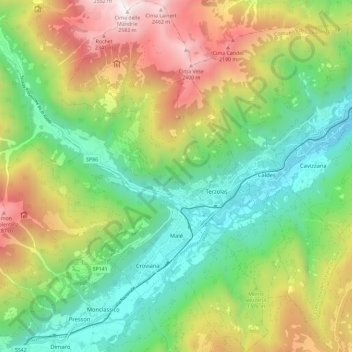
Nom : Carte topographique Malé, altitude, relief.
Altitude moyenne : 1 332 m
Altitude minimum : 595 m
Altitude maximum : 2 560 m
Faire un don
Équipez-vous pour votre prochaine aventure :
En tant que Partenaire Amazon, ce site perçoit une commission sur les achats éligibles sans surcoût pour vous.
Autres cartes topographiques
Cliquez sur une carte pour visualiser sa topographie, son altitude et son relief.
Faire un don
Équipez-vous pour votre prochaine aventure :
En tant que Partenaire Amazon, ce site perçoit une commission sur les achats éligibles sans surcoût pour vous.
Val di Fiemme
Italy > Trentino – Alto Adige/Südtirol > Provincia di Trento > Panchià
Altitude moyenne : 1 640 m
Madonna di Campiglio
Italy > Trentino – Alto Adige/Südtirol > Provincia di Trento
Madonna di Campiglio (German: Sankt Maria im Pein) is a village and a ski resort in northeast Italy. It is a frazione of the comune of Pinzolo. The village lies in the Val Rendena at an elevation of 1,522 m (4,993 ft) above sea level, and has approximately 1,000 inhabitants.
Altitude moyenne : 1 744 m
Faire un don
Équipez-vous pour votre prochaine aventure :
En tant que Partenaire Amazon, ce site perçoit une commission sur les achats éligibles sans surcoût pour vous.
Cortina
Italy > Trentino – Alto Adige/Südtirol > Provincia di Trento > Vermiglio
Altitude moyenne : 1 534 m
Covelo
Italy > Trentino – Alto Adige/Südtirol > Provincia di Trento > Vallelaghi
Altitude moyenne : 834 m
Lago di Molveno
Italy > Trentino – Alto Adige/Südtirol > Provincia di Trento > Molveno
Altitude moyenne : 1 071 m
Faire un don
Équipez-vous pour votre prochaine aventure :
En tant que Partenaire Amazon, ce site perçoit une commission sur les achats éligibles sans surcoût pour vous.
Faire un don
Équipez-vous pour votre prochaine aventure :
En tant que Partenaire Amazon, ce site perçoit une commission sur les achats éligibles sans surcoût pour vous.
Bocca di Valle
Italy > Trentino – Alto Adige/Südtirol > Provincia di Trento > Bondone
Altitude moyenne : 1 258 m
Alpe Cermis
Italy > Trentino – Alto Adige/Südtirol > Provincia di Trento > Cavalese
Altitude moyenne : 1 715 m
Ronchi
Italy > Trentino – Alto Adige/Südtirol > Provincia di Trento > Trento > Mattarello
Altitude moyenne : 339 m
Belvedere
Italy > Trentino – Alto Adige/Südtirol > Provincia di Trento > Pergine Valsugana
Altitude moyenne : 791 m
Faire un don
Équipez-vous pour votre prochaine aventure :
En tant que Partenaire Amazon, ce site perçoit une commission sur les achats éligibles sans surcoût pour vous.
Faire un don
Équipez-vous pour votre prochaine aventure :
En tant que Partenaire Amazon, ce site perçoit une commission sur les achats éligibles sans surcoût pour vous.
Valsorda
Italy > Trentino – Alto Adige/Südtirol > Provincia di Trento > Predazzo
Altitude moyenne : 1 785 m
Biacesa di Ledro
Italy > Trentino – Alto Adige/Südtirol > Provincia di Trento
Altitude moyenne : 831 m
Faire un don
Équipez-vous pour votre prochaine aventure :
En tant que Partenaire Amazon, ce site perçoit une commission sur les achats éligibles sans surcoût pour vous.
Cortina
Italy > Trentino – Alto Adige/Südtirol > Provincia di Trento > Vermiglio
Altitude moyenne : 1 534 m
Saone
Italy > Trentino – Alto Adige/Südtirol > Provincia di Trento > Tione di Trento
Altitude moyenne : 848 m
Karerpass - Jouf de Ciareja - passo Carezza
Italy > Trentino – Alto Adige/Südtirol > Provincia di Trento
Altitude moyenne : 1 869 m
Faire un don
Équipez-vous pour votre prochaine aventure :
En tant que Partenaire Amazon, ce site perçoit une commission sur les achats éligibles sans surcoût pour vous.
Dossone
Italy > Trentino – Alto Adige/Südtirol > Provincia di Trento > Caderzone Terme
Altitude moyenne : 1 639 m
Camin
Italy > Trentino – Alto Adige/Südtirol > Provincia di Trento > Ziano di Fiemme
Altitude moyenne : 2 022 m
Lago di Lagolo
Italy > Trentino – Alto Adige/Südtirol > Provincia di Trento > Lagolo
Altitude moyenne : 1 004 m
Faire un don
Équipez-vous pour votre prochaine aventure :
En tant que Partenaire Amazon, ce site perçoit une commission sur les achats éligibles sans surcoût pour vous.
Carbonare
Italy > Trentino – Alto Adige/Südtirol > Provincia di Trento > San Sebastiano
Altitude moyenne : 1 167 m
Bergner Kreuz - Croce di Forcella Piccola
Italy > Trentino – Alto Adige/Südtirol > Provincia di Trento
Altitude moyenne : 1 433 m
Faire un don
Équipez-vous pour votre prochaine aventure :
En tant que Partenaire Amazon, ce site perçoit une commission sur les achats éligibles sans surcoût pour vous.
Stavel
Italy > Trentino – Alto Adige/Südtirol > Provincia di Trento > Vermiglio
Altitude moyenne : 1 692 m
Cortina
Italy > Trentino – Alto Adige/Südtirol > Provincia di Trento > Vermiglio
Altitude moyenne : 1 534 m
Faire un don
Équipez-vous pour votre prochaine aventure :
En tant que Partenaire Amazon, ce site perçoit une commission sur les achats éligibles sans surcoût pour vous.
valle dell'Anza
Italy > Trentino – Alto Adige/Südtirol > Provincia di Trento > Levico Terme > Selva di Levico > Masi Rossi
Altitude moyenne : 807 m
Mazza di Pichea
Italy > Trentino – Alto Adige/Südtirol > Provincia di Trento
Altitude moyenne : 1 467 m
Madonna di Campiglio
Italy > Trentino – Alto Adige/Südtirol > Provincia di Trento
Madonna di Campiglio (German: Sankt Maria im Pein) is a village and a ski resort in northeast Italy. It is a frazione of the comune of Pinzolo. The village lies in the Val Rendena at an elevation of 1,522 m (4,993 ft) above sea level, and has approximately 1,000 inhabitants.
Altitude moyenne : 1 744 m
Faire un don
Équipez-vous pour votre prochaine aventure :
En tant que Partenaire Amazon, ce site perçoit une commission sur les achats éligibles sans surcoût pour vous.
Pian
Italy > Trentino – Alto Adige/Südtirol > Provincia di Trento > Campitello di Fassa > Campitello di Fassa - Ciampedel
Altitude moyenne : 1 797 m
Pozza di Fassa - Poza
Italy > Trentino – Alto Adige/Südtirol > Provincia di Trento
Altitude moyenne : 1 583 m
Passo Tonale
Italy > Trentino – Alto Adige/Südtirol > Provincia di Trento > Vermiglio
Altitude moyenne : 2 064 m
Faire un don
Équipez-vous pour votre prochaine aventure :
En tant que Partenaire Amazon, ce site perçoit une commission sur les achats éligibles sans surcoût pour vous.
Vigo di Fassa - Vich
Italy > Trentino – Alto Adige/Südtirol > Provincia di Trento
Altitude moyenne : 1 600 m
Nanno
Italy > Trentino – Alto Adige/Südtirol > Provincia di Trento > Ville d'Anaunia
Altitude moyenne : 534 m
Alboletta
Italy > Trentino – Alto Adige/Südtirol > Provincia di Trento > Riva del Garda > Sant'Alessandro
Altitude moyenne : 239 m
Faire un don
Équipez-vous pour votre prochaine aventure :
En tant que Partenaire Amazon, ce site perçoit une commission sur les achats éligibles sans surcoût pour vous.
Costasavina
Italy > Trentino – Alto Adige/Südtirol > Provincia di Trento > Pergine Valsugana > Susà
Altitude moyenne : 626 m