
Faire un don
Équipez-vous pour votre prochaine aventure :
En tant que Partenaire Amazon, ce site perçoit une commission sur les achats éligibles sans surcoût pour vous.
Carte topographique Fondo
Cliquez sur la carte pour afficher l’altitude.
Faire un don
Équipez-vous pour votre prochaine aventure :
En tant que Partenaire Amazon, ce site perçoit une commission sur les achats éligibles sans surcoût pour vous.
À propos de cette carte
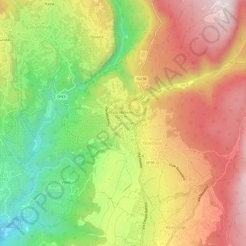
Nom : Carte topographique Fondo, altitude, relief.
Altitude moyenne : 1 002 m
Altitude minimum : 645 m
Altitude maximum : 1 339 m
Faire un don
Équipez-vous pour votre prochaine aventure :
En tant que Partenaire Amazon, ce site perçoit une commission sur les achats éligibles sans surcoût pour vous.
Autres cartes topographiques
Cliquez sur une carte pour visualiser sa topographie, son altitude et son relief.
Trento
Italy > Trentino – Alto Adige/Südtirol > Provincia di Trento
The municipality of Trento stretches across a wide range of altitude levels, going from just under 200 m above sea level at the city centre, to 400 m in Povo and Cognola, to 2000 m above sea level at Monte Bondone, boroughs at higher elevation, for instance Viote, have a colder alpine climate (Dw). Urban…
Altitude moyenne : 789 m
Fiera di Primiero
Italy > Trentino – Alto Adige/Südtirol > Provincia di Trento
Altitude moyenne : 878 m
Faire un don
Équipez-vous pour votre prochaine aventure :
En tant que Partenaire Amazon, ce site perçoit une commission sur les achats éligibles sans surcoût pour vous.
Trento
Italy > Trentino – Alto Adige/Südtirol > Provincia di Trento
The municipality of Trento stretches across a wide range of altitude levels, going from just under 200 m above sea level at the city centre, to 400 m in Povo and Cognola, to 2000 m above sea level at Monte Bondone, boroughs at higher elevation, for instance Viote, have a colder alpine climate (Dw). Urban…
Altitude moyenne : 789 m
Val di Fiemme
Italy > Trentino – Alto Adige/Südtirol > Provincia di Trento > Panchià
Altitude moyenne : 1 640 m
Faire un don
Équipez-vous pour votre prochaine aventure :
En tant que Partenaire Amazon, ce site perçoit une commission sur les achats éligibles sans surcoût pour vous.
Faire un don
Équipez-vous pour votre prochaine aventure :
En tant que Partenaire Amazon, ce site perçoit une commission sur les achats éligibles sans surcoût pour vous.
Faire un don
Équipez-vous pour votre prochaine aventure :
En tant que Partenaire Amazon, ce site perçoit une commission sur les achats éligibles sans surcoût pour vous.
Castello Tesino
Italy > Trentino – Alto Adige/Südtirol > Provincia di Trento
Altitude moyenne : 1 350 m
Faire un don
Équipez-vous pour votre prochaine aventure :
En tant que Partenaire Amazon, ce site perçoit une commission sur les achats éligibles sans surcoût pour vous.
Lago di Molveno
Italy > Trentino – Alto Adige/Südtirol > Provincia di Trento > Molveno
Altitude moyenne : 1 071 m
Levico Terme
Italy > Trentino – Alto Adige/Südtirol > Provincia di Trento
The town is dominated by the mountains of the Lagorai range on the north, with Monte Fronte, elevation 1,582 metres (5,190 ft), and Monte Panarotta (2,002 metres (6,568 ft)), and the zone of the Plateaus (Vezzena, Lavarone, Luserna, Folgaria) on the south, where Cima Vezzena, also locally called Pizzo di…
Altitude moyenne : 952 m
Faire un don
Équipez-vous pour votre prochaine aventure :
En tant que Partenaire Amazon, ce site perçoit une commission sur les achats éligibles sans surcoût pour vous.
Faire un don
Équipez-vous pour votre prochaine aventure :
En tant que Partenaire Amazon, ce site perçoit une commission sur les achats éligibles sans surcoût pour vous.
Sella group
Italy > Trentino – Alto Adige/Südtirol > Provincia di Trento > Canazei
Altitude moyenne : 2 120 m
Borgo Valsugana
Italy > Trentino – Alto Adige/Südtirol > Provincia di Trento
Altitude moyenne : 1 082 m
Faire un don
Équipez-vous pour votre prochaine aventure :
En tant que Partenaire Amazon, ce site perçoit une commission sur les achats éligibles sans surcoût pour vous.
Fiera di Primiero
Italy > Trentino – Alto Adige/Südtirol > Provincia di Trento
Altitude moyenne : 878 m
Faire un don
Équipez-vous pour votre prochaine aventure :
En tant que Partenaire Amazon, ce site perçoit une commission sur les achats éligibles sans surcoût pour vous.
Valsorda
Italy > Trentino – Alto Adige/Südtirol > Provincia di Trento > Predazzo
Altitude moyenne : 1 785 m
Ville d'Anaunia
Italy > Trentino – Alto Adige/Südtirol > Provincia di Trento
Altitude moyenne : 1 457 m
San Martino di Castrozza
Italy > Trentino – Alto Adige/Südtirol > Provincia di Trento
Altitude moyenne : 2 005 m
Faire un don
Équipez-vous pour votre prochaine aventure :
En tant que Partenaire Amazon, ce site perçoit une commission sur les achats éligibles sans surcoût pour vous.
Lago di Lagolo
Italy > Trentino – Alto Adige/Südtirol > Provincia di Trento > Lagolo
Altitude moyenne : 1 004 m
Faire un don
Équipez-vous pour votre prochaine aventure :
En tant que Partenaire Amazon, ce site perçoit une commission sur les achats éligibles sans surcoût pour vous.
Canal San Bovo
Italy > Trentino – Alto Adige/Südtirol > Provincia di Trento
Altitude moyenne : 1 547 m
Faire un don
Équipez-vous pour votre prochaine aventure :
En tant que Partenaire Amazon, ce site perçoit une commission sur les achats éligibles sans surcoût pour vous.
valle dell'Anza
Italy > Trentino – Alto Adige/Südtirol > Provincia di Trento > Levico Terme > Selva di Levico > Masi Rossi
Altitude moyenne : 807 m
Faire un don
Équipez-vous pour votre prochaine aventure :
En tant que Partenaire Amazon, ce site perçoit une commission sur les achats éligibles sans surcoût pour vous.
Pinzolo
Italy > Trentino – Alto Adige/Südtirol > Provincia di Trento
Pinzolo (Eastern Lombard: Pinsöl) is a small town and comune situated in Val Rendena in Trentino in the northern Italian Alps at an elevation of 800 metres (2,600 ft). The Church of Saint Vigilius of Trent stands in the town.
Altitude moyenne : 1 924 m
Trento
Italy > Trentino – Alto Adige/Südtirol > Provincia di Trento
The municipality of Trento stretches across a wide range of altitude levels, going from just under 200 m above sea level at the city centre, to 400 m in Povo and Cognola, to 2000 m above sea level at Monte Bondone, boroughs at higher elevation, for instance Viote, have a colder alpine climate (Dw). Urban…
Altitude moyenne : 789 m
Faire un don
Équipez-vous pour votre prochaine aventure :
En tant que Partenaire Amazon, ce site perçoit une commission sur les achats éligibles sans surcoût pour vous.