
Carte topographique Metcalfe County
Carte interactive
Cliquez sur la carte pour afficher l’altitude.
À propos de cette carte
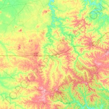
Nom : Carte topographique Metcalfe County, altitude, relief.
Lieu : Metcalfe County, Kentucky, United States of America (36.81869 -85.77706 37.18220 -85.44180)
Altitude moyenne : 251 m
Altitude minimum : 165 m
Altitude maximum : 354 m
Autres cartes topographiques
Cliquez sur une carte pour visualiser sa topographie, son altitude et son relief.
High Plains
United States of America > Kentucky > High Plains
High Plains, Breckinridge County, Kentucky, 40115, United States of America
Altitude moyenne : 228 m
Covington
United States of America > Kentucky > Covington
Covington, Kenton County, Kentucky, United States of America
Altitude moyenne : 215 m
Pineville
United States of America > Kentucky > Pineville
Pineville, Bell County, Kentucky, United States of America
Altitude moyenne : 426 m
Ready
United States of America > Kentucky > Ready
Ready, Grayson County, Kentucky, United States of America
Altitude moyenne : 206 m
Monroe County
United States of America > Kentucky
Monroe County, Kentucky, United States of America
Altitude moyenne : 250 m
Cumberland County
United States of America > Kentucky
Cumberland County, Kentucky, United States of America
Altitude moyenne : 237 m
Pomp
United States of America > Kentucky > Pomp
Pomp, Morgan County, Kentucky, 41472, United States of America
Altitude moyenne : 282 m
Lawrenceburg
United States of America > Kentucky > Lawrenceburg > Lawrenceburg
Lawrenceburg, Anderson County, Kentucky, 40342, United States of America
Altitude moyenne : 244 m
Millard
United States of America > Kentucky > Millard
Nelse, Millard, Pike County, Kentucky, 41562, United States of America
Altitude moyenne : 315 m