
Carte topographique Leedstown
Carte interactive
Cliquez sur la carte pour afficher l’altitude.
À propos de cette carte
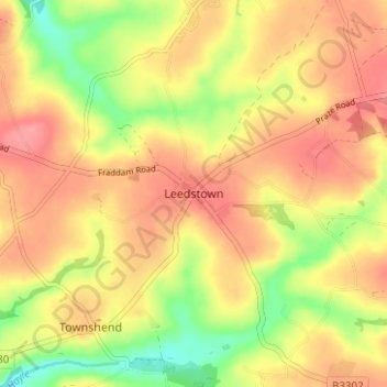
Nom : Carte topographique Leedstown, altitude, relief.
Lieu : Leedstown, Cornwall, England, TR27 6DB, United Kingdom (50.14074 -5.37560 50.18074 -5.33560)
Altitude moyenne : 73 m
Altitude minimum : 27 m
Altitude maximum : 103 m
Autres cartes topographiques
Cliquez sur une carte pour visualiser sa topographie, son altitude et son relief.
Perranporth
United Kingdom > England > Cornwall
Perranporth, Perranzabuloe, Cornwall, England, TR6 0HR, United Kingdom
Altitude moyenne : 43 m
Polkerris
United Kingdom > England > Cornwall > Fowey
Polkerris, Fowey, Cornwall, England, PL24 2TL, United Kingdom
Altitude moyenne : 35 m
Bude
United Kingdom > England > Cornwall
Bude, Cornwall, England, EX23 8LD, United Kingdom
Altitude moyenne : 39 m