Géolocaliser
👉 Easily get elevation data in JSON, GeoTIFF and KML formats using Elevation API
Merci de soutenir ce site ❤️
Faire un don
🎯 Votre prochain emploi est peut-être à un message près : emploichat.fr

Carte topographique Thistleton

Cliquez sur la carte pour afficher l’altitude.

👉 Easily get elevation data in JSON, GeoTIFF and KML formats using Elevation API
Merci de soutenir ce site ❤️
Faire un don
🎯 Votre prochain emploi est peut-être à un message près : emploichat.fr

À propos de cette carte

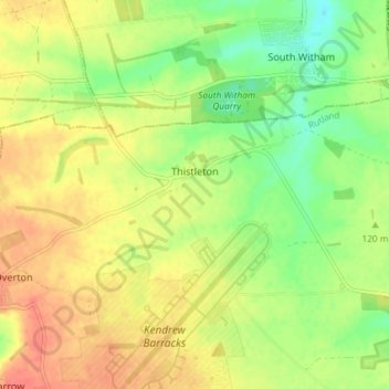
Nom : Carte topographique Thistleton, altitude, relief.

Lieu : Thistleton, Rutland, England, United Kingdom (52.73791 -0.67812 52.75982 -0.60530)

Altitude moyenne : 125 m

Altitude minimum : 98 m

Altitude maximum : 148 m

Autres cartes topographiques

Cliquez sur une carte pour visualiser sa topographie, son altitude et son relief.

Toll Bar

United Kingdom > England > Rutland

Altitude moyenne : 61 m

Cold Overton

United Kingdom > England > Rutland > Melton

Altitude moyenne : 171 m

Oakham Canal

United Kingdom > England > Rutland > Oakham

Altitude moyenne : 115 m

Tinwell

United Kingdom > England > Rutland

Altitude moyenne : 58 m

Lyddington

United Kingdom > England > Rutland

Altitude moyenne : 93 m

Langham

United Kingdom > England > Rutland

Altitude moyenne : 135 m

Belton-in-Rutland

United Kingdom > England > Rutland

Altitude moyenne : 134 m

Belmesthorpe

United Kingdom > England > Rutland

Altitude moyenne : 39 m

Exton

United Kingdom > England > Rutland

Altitude moyenne : 113 m

Brooke

United Kingdom > England > Rutland

Altitude moyenne : 125 m

Seaton

United Kingdom > England > Rutland > Seaton

Altitude moyenne : 77 m

Horn Mill Spinney

United Kingdom > England > Rutland > Empingham

Altitude moyenne : 88 m

Merci de soutenir ce site ❤️
Faire un don
🎯 Votre prochain emploi est peut-être à un message près : emploichat.fr

Caldecott

United Kingdom > England > Rutland > Caldecott

Altitude moyenne : 66 m

Ridlington

United Kingdom > England > Rutland > Ridlington

Altitude moyenne : 129 m

Équipez-vous pour votre prochaine aventure :

🧭Boussoles professionnelles - Boussoles de précision pour navigation avancée et survie
🛰️Balises GPS - Dispositifs de sécurité et de localisation
🧴Crème Solaire Sport - Haute protection résistante à la transpiration pour les sommets
🗺️Cartes topographiques - Cartes détaillées pour préparer itinéraires et randonnées
🥤Gourdes de randonnée - Gourdes légères pour hydratation en marche

En tant que Partenaire Amazon, ce site perçoit une commission sur les achats éligibles sans surcoût pour vous.