Géolocaliser

Carte topographique Netherfield

Cliquez sur la carte pour afficher l’altitude.

À propos de cette carte

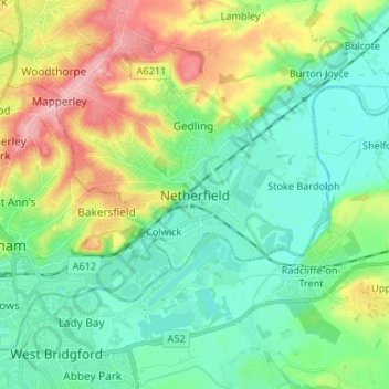
Nom : Carte topographique Netherfield, altitude, relief.

Lieu : Netherfield, Gedling, Nottinghamshire, East Midlands, England, NG4 2FF, United Kingdom (52.92369 -1.11839 53.00369 -1.03839)

Altitude moyenne : 48 m

Altitude minimum : 11 m

Altitude maximum : 130 m

Autres cartes topographiques

Cliquez sur une carte pour visualiser sa topographie, son altitude et son relief.

Calverton CP

United Kingdom > England > Nottinghamshire > Gedling

Altitude moyenne : 80 m

Ravenshead CP

United Kingdom > England > Nottinghamshire > Gedling

Altitude moyenne : 123 m

Linby CP

United Kingdom > England > Nottinghamshire > Gedling

Altitude moyenne : 97 m

Woodborough

United Kingdom > England > Nottinghamshire > Gedling

Altitude moyenne : 73 m

Newstead CP

United Kingdom > England > Nottinghamshire > Gedling

Altitude moyenne : 139 m

Calverton CP

United Kingdom > England > Nottinghamshire > Gedling

Altitude moyenne : 81 m

Newstead CP

United Kingdom > England > Nottinghamshire > Gedling

Altitude moyenne : 139 m

Équipez-vous pour votre prochaine aventure :

🗺️Cartes IGN - Cartes IGN officielles pour randonnée et orientation en France
🔌Panneau Solaire Pliable - Source d'énergie autonome pour les treks de plusieurs jours
🧭Boussoles professionnelles - Boussoles de précision pour navigation avancée et survie
📍GPS de randonnée - GPS fiables pour suivre itinéraires et traces en pleine nature
🗺️Porte-cartes randonnée - Protection étanche pour cartes papier

En tant que Partenaire Amazon, ce site perçoit une commission sur les achats éligibles sans surcoût pour vous.