
Carte topographique Entebbe City
Carte interactive
Cliquez sur la carte pour afficher l’altitude.
À propos de cette carte
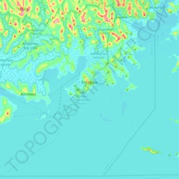
Nom : Carte topographique Entebbe City, altitude, relief.
Lieu : Entebbe City, Wakiso, Central Region, Uganda (-0.15304 32.21198 0.24197 32.61936)
Altitude moyenne : 1 146 m
Altitude minimum : 1 129 m
Altitude maximum : 1 328 m
Entebbe experiences tropical rainforest climate (Af) according to the Köppen climate classification as the city has no real dry season throughout the year. The driest season is January with precipitation total 65 millimetres (2.6 in), while the wettest season is April with precipitation total 256 millimetres (10.1 in). The temperature is moderated by the altitude. The hottest month is February with average temperature 22.8 °C (73.0 °F), while the coolest month is July with average temperature 20.6 °C (69.1 °F).
Autres cartes topographiques
Cliquez sur une carte pour visualiser sa topographie, son altitude et son relief.
Kireku Railway
Kireku Railway, Wakiso, Central Region, Uganda
Altitude moyenne : 1 161 m
Lyamutundwe
Uganda > Wakiso > Lyamutundwe
Lyamutundwe, Wakiso, Central Region, P.O. BOX 182 - ENTEBBE, Uganda
Altitude moyenne : 1 155 m