
Carte topographique Kechnec
Carte interactive
Cliquez sur la carte pour afficher l’altitude.
À propos de cette carte
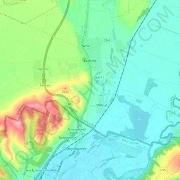
Nom : Carte topographique Kechnec, altitude, relief.
Altitude moyenne : 188 m
Altitude minimum : 154 m
Altitude maximum : 281 m
The village lies at an altitude of 180 metres and covers an area of 10.211 km2. The municipality is part of the administrative units Košice-okolie District and Košice Region. It has a population of about 1080 people.
Autres cartes topographiques
Cliquez sur une carte pour visualiser sa topographie, son altitude et son relief.
Čečejovce
Slovakia > Region of Košice > District of Košice - okolie
Čečejovce, District of Košice - okolie, Region of Košice, Eastern Slovakia, 044 71, Slovakia
Altitude moyenne : 217 m