
Carte topographique Tandridge District
Carte interactive
Cliquez sur la carte pour afficher l’altitude.
À propos de cette carte
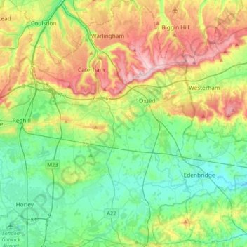
Nom : Carte topographique Tandridge District, altitude, relief.
Altitude moyenne : 114 m
Altitude minimum : 34 m
Altitude maximum : 271 m
The district contains parts of the North Downs Area of Outstanding Natural Beauty and the Weald. It also contains several woodlands and some open heathland. Elevations above sea level range from 267 m (876 ft) at Botley Hill, in the North Downs near Oxted, to 42 m (138 ft) near Edenbridge.
Autres cartes topographiques
Cliquez sur une carte pour visualiser sa topographie, son altitude et son relief.
Nutfield
United Kingdom > England > Surrey > Tandridge District
Nutfield, Tandridge District, Surrey, England, United Kingdom
Altitude moyenne : 88 m
Warlingham
United Kingdom > England > Surrey > Tandridge District
Warlingham, Tandridge District, Surrey, England, United Kingdom
Altitude moyenne : 163 m
Caterham
United Kingdom > England > Surrey > Tandridge District
Caterham, Tandridge District, Surrey, England, CR3 6XS, United Kingdom
Altitude moyenne : 157 m