
Carte topographique Caterham
Carte interactive
Cliquez sur la carte pour afficher l’altitude.
À propos de cette carte
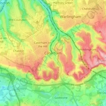
Nom : Carte topographique Caterham, altitude, relief.
Altitude moyenne : 157 m
Altitude minimum : 70 m
Altitude maximum : 270 m
In 1840 Caterham contained a total of 477 residents (figures taken from that census, compiled in an 1848 topographical encyclopedia) and in 1848 468 acres (189 ha) of its 2,386 acres (966 ha) were common land. Similar to today, 175 acres (71 ha) mostly steeper acres were woodland.
Autres cartes topographiques
Cliquez sur une carte pour visualiser sa topographie, son altitude et son relief.
Tandridge District
United Kingdom > England > Surrey > Tandridge District
Tandridge District, Surrey, South East England, England, United Kingdom
Altitude moyenne : 114 m
Nutfield
United Kingdom > England > Surrey > Tandridge District
Nutfield, Tandridge District, Surrey, England, United Kingdom
Altitude moyenne : 88 m
Warlingham
United Kingdom > England > Surrey > Tandridge District
Warlingham, Tandridge District, Surrey, England, United Kingdom
Altitude moyenne : 163 m