
Carte topographique Böhen
Carte interactive
Cliquez sur la carte pour afficher l’altitude.
À propos de cette carte
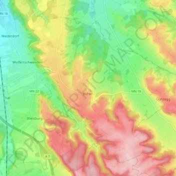
Nom : Carte topographique Böhen, altitude, relief.
Altitude moyenne : 745 m
Altitude minimum : 649 m
Altitude maximum : 854 m
Autres cartes topographiques
Cliquez sur une carte pour visualiser sa topographie, son altitude et son relief.
Legau
Deutschland > Bayern > Landkreis Unterallgäu
Legau, Illerwinkel, Landkreis Unterallgäu, Bayern, 87764, Deutschland
Altitude moyenne : 675 m