
Carte topographique Village of Alfred
Carte interactive
Cliquez sur la carte pour afficher l’altitude.
À propos de cette carte
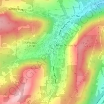
Nom : Carte topographique Village of Alfred, altitude, relief.
Altitude moyenne : 597 m
Altitude minimum : 494 m
Altitude maximum : 686 m
According to the United States Census Bureau, the village has a total area of 1.2 square miles (3.1 km2), all land. A small stream, Kanakadea Creek, flows through the center of the village, then to the Canisteo River, part of the Susquehanna River watershed. The topography is steep hill country, part of the Allegheny Plateau, a physiographic region that is part of the Appalachian Mountains.
Autres cartes topographiques
Cliquez sur une carte pour visualiser sa topographie, son altitude et son relief.
Town of Grove
United States > New York > Allegany County
Town of Grove, Allegany County, New York, 14884, United States
Altitude moyenne : 563 m
Town of Birdsall
United States > New York > Allegany County
Town of Birdsall, Allegany County, New York, United States
Altitude moyenne : 581 m
Town of Wellsville
United States > New York > Allegany County
Town of Wellsville, Allegany County, New York, 14895, United States
Altitude moyenne : 564 m
Village of Andover
United States > New York > Allegany County
Village of Andover, Town of Andover, Allegany County, New York, 14806, United States
Altitude moyenne : 561 m
Town of Rushford
United States > New York > Allegany County
Town of Rushford, Allegany County, New York, United States
Altitude moyenne : 528 m
Swain
United States > New York > Allegany County
Swain, Town of Grove, Allegany County, New York, 14884, United States
Altitude moyenne : 503 m
Almond
United States > New York > Allegany County > Almond
Almond, Allegany County, New York, United States
Altitude moyenne : 470 m
Birdsall
United States > New York > Allegany County
Birdsall, Town of Birdsall, Allegany County, New York, United States
Altitude moyenne : 582 m