
Carte topographique Town of Rushford
Carte interactive
Cliquez sur la carte pour afficher l’altitude.
À propos de cette carte
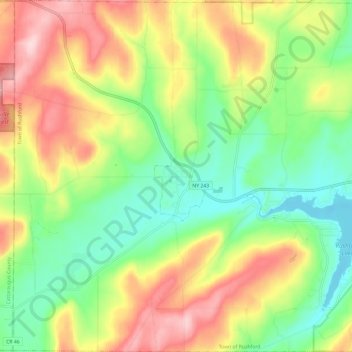
Nom : Carte topographique Town of Rushford, altitude, relief.
Lieu : Town of Rushford, Allegany County, New York, United States (42.34862 -78.30903 42.43661 -78.19132)
Altitude moyenne : 528 m
Altitude minimum : 430 m
Altitude maximum : 666 m
Autres cartes topographiques
Cliquez sur une carte pour visualiser sa topographie, son altitude et son relief.
Town of Grove
United States > New York > Allegany County
Town of Grove, Allegany County, New York, 14884, United States
Altitude moyenne : 563 m
Town of Birdsall
United States > New York > Allegany County
Town of Birdsall, Allegany County, New York, United States
Altitude moyenne : 581 m
Village of Alfred
United States > New York > Allegany County
Village of Alfred, Town of Alfred, Allegany County, New York, 14802, United States
Altitude moyenne : 597 m
Town of Wellsville
United States > New York > Allegany County
Town of Wellsville, Allegany County, New York, 14895, United States
Altitude moyenne : 564 m
Village of Andover
United States > New York > Allegany County
Village of Andover, Town of Andover, Allegany County, New York, 14806, United States
Altitude moyenne : 561 m
Swain
United States > New York > Allegany County
Swain, Town of Grove, Allegany County, New York, 14884, United States
Altitude moyenne : 503 m
Almond
United States > New York > Allegany County > Almond
Almond, Allegany County, New York, United States
Altitude moyenne : 470 m
Birdsall
United States > New York > Allegany County
Birdsall, Town of Birdsall, Allegany County, New York, United States
Altitude moyenne : 582 m