
Carte topographique Castleknock
Carte interactive
Cliquez sur la carte pour afficher l’altitude.
À propos de cette carte
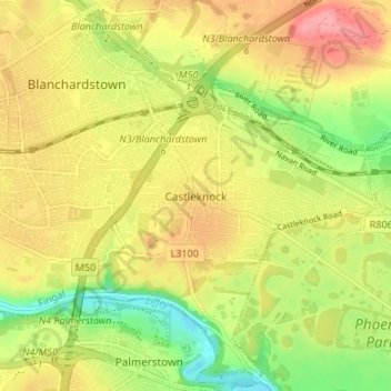
Nom : Carte topographique Castleknock, altitude, relief.
Lieu : Castleknock, Fingal, Dublin 15, Leinster, D15 VY32, Irland (53.35296 -6.38247 53.39296 -6.34247)
Altitude moyenne : 55 m
Altitude minimum : 7 m
Altitude maximum : 98 m
Autres cartes topographiques
Cliquez sur une carte pour visualiser sa topographie, son altitude et son relief.
Lower Lough Bray
Lower Lough Bray, Powerscourt ED, The Municipal District of Bray, County Wicklow, Leinster, Irland
Altitude moyenne : 455 m
Eagle's Crag
Eagle's Crag, Powerscourt ED, The Municipal District of Bray, County Wicklow, Leinster, Irland
Altitude moyenne : 490 m
The Municipal District of Wicklow
The Municipal District of Wicklow, County Wicklow, Leinster, Irland
Altitude moyenne : 263 m
Glencullen ED
Glencullen ED, Dublin 18, Dún Laoghaire-Rathdown, County Dublin, Leinster, Irland
Altitude moyenne : 137 m
Dingle - Daingean Uí Chúis
Irland > Dingle - Daingean Uí Chúis
Dingle - Daingean Uí Chúis, County Kerry, Munster, Irland
Altitude moyenne : 77 m
Attimonmore South
Attimonmore South, Cloonkeen ED, Athenry-Oranmore Municipal District, County Galway, Connacht, Irland
Altitude moyenne : 75 m
North Bull Island
North Bull Island, Raheny St. Assam ED, Dublin 5, Dublin, County Dublin, Leinster, Irland
Altitude moyenne : 2 m
Valentia Island
Valentia Island, Kenmare Municipal District, County Kerry, Munster, Irland
Altitude moyenne : 39 m