
Carte topographique Tibériade
Carte interactive
Cliquez sur la carte pour afficher l’altitude.
À propos de cette carte
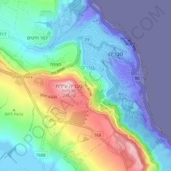
Nom : Carte topographique Tibériade, altitude, relief.
Lieu : Tibériade, נפת כנרת, District nord, 1424224, Israël (32.75402 35.49528 32.81215 35.56298)
Altitude moyenne : -48 m
Altitude minimum : -218 m
Altitude maximum : 249 m
Autres cartes topographiques
Cliquez sur une carte pour visualiser sa topographie, son altitude et son relief.
Kiryat Shmona
Kiryat Shmona, Sous-district de Safed, District nord, Israël
Altitude moyenne : 236 m
Lac de Tibériade
Lac de Tibériade, נפת כנרת, District nord, Israël
Altitude moyenne : -67 m
Plateau du Golan
Plateau du Golan, District nord, Israël
Altitude moyenne : 524 m
Golan
Israël > District nord > Golan
Golan, נפת רמת הגולן, District nord, Israël
Altitude moyenne : 524 m
Amir
Israël > District nord > Haute Galilée
Amir, Haute Galilée, נפת צפת, District nord, Israël
Altitude moyenne : 78 m
Plateau du Golan
Israël > District nord > Golan
Plateau du Golan, Golan, Plateau du Golan, District nord, Israël
Altitude moyenne : 533 m
Alonei Abba
Israël > District nord > Conseil régional de la vallée de Jezreel
Alonei Abba, Conseil régional de la vallée de Jezreel, נפת יזרעאל, District nord, Israël
Altitude moyenne : 149 m
Acre
Israël > District nord > Acre
Acre, נפת עכו, District nord, 2451308, Israël
Altitude moyenne : 74 m
Kinneret
Israël > District nord > Conseil régional d'Emek HaYarden
Kinneret, Conseil régional d'Emek HaYarden, נפת כנרת, District nord, Israël
Altitude moyenne : -134 m
Megiddo
Israël > District nord > Megiddo
Megiddo, 66, Megiddo, נפת יזרעאל, District nord, no, Israël
Altitude moyenne : 129 m
Kafr Cana
Israël > District nord > Kafr Cana
Kafr Cana, נפת יזרעאל, District nord, 16930, Israël
Altitude moyenne : 240 m
Réserve naturelle du mont Avital et mont Bentel
Israël > District nord > Golan > Merom Golan
Réserve naturelle du mont Avital et mont Bentel, Merom Golan, Golan, נפת רמת הגולן, District nord, Israël
Altitude moyenne : 968 m
Sa'ar
Israël > District nord > Conseil régional de Mateh Asher > Sa'ar
Sa'ar, Conseil régional de Mateh Asher, נפת עכו, District nord, Israël
Altitude moyenne : 15 m
Capharnaüm
Israël > District nord > Conseil régional d'Emek HaYarden
Capharnaüm, 87, Conseil régional d'Emek HaYarden, נפת כנרת, District nord, 14100, Israël
Altitude moyenne : -181 m
Tel Haï
Israël > District nord > Haute Galilée
Tel Haï, Haute Galilée, נפת צפת, District nord, 1156852, Israël
Altitude moyenne : 288 m
טבח'ה
Israël > District nord > מועצה אזורית עמק הירדן > טבח'ה
טבח'ה, מועצה אזורית עמק הירדן, נפת כנרת, District nord, 14100, Israël
Altitude moyenne : -151 m
Karmiel
Israël > District nord > Karmiel
Karmiel, נפת עכו, District nord, Israël
Altitude moyenne : 315 m
الشبلي-أم الغنم
Israël > District nord > الشبلي-أم الغنم
الشبلي-أم الغنم, נפת יזרעאל, District nord, Israël
Altitude moyenne : 178 m
Shefa'ram
Israël > District nord > Shefa'ram
Shefa'ram, נפת עכו, District nord, Israël
Altitude moyenne : 119 m
מועצה אזורית מרום הגליל
Israël > District nord > מועצה אזורית מרום הגליל
מועצה אזורית מרום הגליל, District nord, 20107, Israël
Altitude moyenne : 448 m
מועצה אזורית עמק הירדן
Israël > District nord > מועצה אזורית עמק הירדן
מועצה אזורית עמק הירדן, District nord, Israël
Altitude moyenne : 103 m
Qiryat Shemona
Israël > District nord > Qiryat Shemona
Qiryat Shemona, District nord, Israël
Altitude moyenne : 283 m
Haute Galilée
Haute Galilée, Sous-district de Safed, District nord, Israël
Altitude moyenne : 508 m
המפל השחור
Israël > District nord > מועצה אזורית גולן
המפל השחור, מועצה אזורית גולן, District nord, 1292000, Israël
Altitude moyenne : 377 m