
Carte topographique Paravur
Carte interactive
Cliquez sur la carte pour afficher l’altitude.
À propos de cette carte
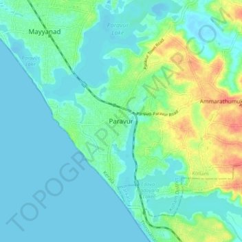
Nom : Carte topographique Paravur, altitude, relief.
Lieu : Paravur, Kollam, Kerala, 691301, India (8.76989 76.63153 8.84989 76.71153)
Altitude moyenne : 14 m
Altitude minimum : -5 m
Altitude maximum : 60 m
Paravur is located at 8.78 N 76 E. It has an average elevation of 10 metres (32 feet). Paravur, 21 kilometers from the Kollam, is a narrow skirt of land stretching in between the backwaters and the sea. There is an elevation of 6 metres above sea level, extending to 16 metres on the inland. Ithikkara river is flowing through paravur. Nedungolam in paravur is now famous for mangrove forest.
Autres cartes topographiques
Cliquez sur une carte pour visualiser sa topographie, son altitude et son relief.
Ashtamudi
India > Kerala > Kollam > Thrikkaruva
Ashtamudi, Thrikkaruva, Kollam, Kollam District, Kerala, 691602, India
Altitude moyenne : 7 m
Chirakkara
Chirakkara, Kollam, Kollam District, Kerala, 691578, India
Altitude moyenne : 36 m
Ashtamudi Lake
India > Kerala > Kollam > Kottayathukadavu
Ashtamudi Lake, Kottayathukadavu, Kollam, Kerala, India
Altitude moyenne : 6 m
Kizhakkekallada
Kizhakkekallada, Kollam, Kerala, 691502, India
Altitude moyenne : 10 m
Kalluvathukkal
Kalluvathukkal, Kollam, Kerala, 691578, India
Altitude moyenne : 40 m
Anchalummood
Anchalummood, Kollam, Kerala, 691601, India
Altitude moyenne : 10 m
Nellimukku
India > Kerala > Kollam > Kollam
Nellimukku, Kaankathu, Thangasseri, Kollam, Kerala, 691001, India
Altitude moyenne : 10 m