
Carte topographique Raspberry Island
Carte interactive
Cliquez sur la carte pour afficher l’altitude.
À propos de cette carte
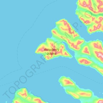
Nom : Carte topographique Raspberry Island, altitude, relief.
Lieu : Raspberry Island, Kodiak Island, Alaska, United States (57.97689 -153.41991 58.14824 -152.91793)
Altitude moyenne : 71 m
Altitude minimum : -4 m
Altitude maximum : 725 m
Sitka spruce is one of the dominant trees on Raspberry Island. Spruce forests are interrupted by fields of salmonberry bushes, alders and wildflowers. Higher elevations have wild blueberry and cranberry bushes with more grasses. Wildlife of note on the island includes Sitka deer, red foxes and Kodiak bears, as well as tufted puffins and bald eagles. Afognak and Raspberry islands are the only locations in Alaska with elk populations. The island's Roosevelt Elk developed from eight calves translocated from Washington state's Olympic Peninsula in 1928. The elk have adapted well to the island, with some mature bulls weighing nearly 1,300 pounds (590 kg). The muskrat is another species that was successfully introduced to the island. Whales commonly meander down Raspberry Strait but must turn around because it becomes too shallow for them to pass all the way through. Kayakers take advantage of this phenomenon to wait for them to pass by again on their way back out to deeper water. Bald eagles are abundant.
Autres cartes topographiques
Cliquez sur une carte pour visualiser sa topographie, son altitude et son relief.
Woody Island
United States > Alaska > Kodiak Island
Woody Island, Kodiak Island, Alaska, United States
Altitude moyenne : 9 m
Trident Volcano
United States > Alaska > Kodiak Island
Trident Volcano, Kodiak Island, Alaska, United States
Altitude moyenne : 1 338 m
Mount Katmai
United States > Alaska > Kodiak Island
Mount Katmai, Kodiak Island, Alaska, United States
Altitude moyenne : 1 507 m
Kodiak
United States > Alaska > Kodiak Island
Kodiak, Kodiak Island, Alaska, United States
Altitude moyenne : 62 m