
Carte topographique Trident Volcano
Carte interactive
Cliquez sur la carte pour afficher l’altitude.
À propos de cette carte
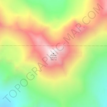
Nom : Carte topographique Trident Volcano, altitude, relief.
Lieu : Trident Volcano, Kodiak Island, Alaska, United States (58.23425 -155.10265 58.23435 -155.10255)
Altitude moyenne : 1 338 m
Altitude minimum : 857 m
Altitude maximum : 1 845 m
Trident Volcano is an eroded volcanic complex on the Alaska Peninsula in Katmai National Park, Alaska. Up to 23 domes comprise the complex stratovolcano, with the greatest elevation of 6,115 feet (1,864 m). The most recent major activity produced a 3,599-foot (1,097 m) dome in an amphitheater on the southwest flank of the southwest peak. Volcano Novarupta formed on its slopes in the largest volcanic eruption of the 20th century.
Autres cartes topographiques
Cliquez sur une carte pour visualiser sa topographie, son altitude et son relief.
Raspberry Island
United States > Alaska > Kodiak Island
Raspberry Island, Kodiak Island, Alaska, United States
Altitude moyenne : 71 m
Woody Island
United States > Alaska > Kodiak Island
Woody Island, Kodiak Island, Alaska, United States
Altitude moyenne : 9 m
Mount Katmai
United States > Alaska > Kodiak Island
Mount Katmai, Kodiak Island, Alaska, United States
Altitude moyenne : 1 507 m
Kodiak
United States > Alaska > Kodiak Island
Kodiak, Kodiak Island, Alaska, United States
Altitude moyenne : 62 m