
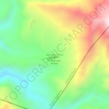
Carte topographique Andakombe
Carte interactive
Cliquez sur la carte pour afficher l’altitude.
À propos de cette carte
Nom : Carte topographique Andakombe, altitude, relief.
Altitude moyenne : 1 153 m
Altitude minimum : 744 m
Altitude maximum : 1 745 m
Autres cartes topographiques
Cliquez sur une carte pour visualiser sa topographie, son altitude et son relief.
Goroka
Papua New Guinea > Eastern Highlands > Goroka District
Goroka, Goroka District, Eastern Highlands, Highlands Region, Papua New Guinea
Altitude moyenne : 1 890 m
Obura Wonenara District
Papua New Guinea > Eastern Highlands
Obura Wonenara District, Eastern Highlands, Highlands Region, Papua New Guinea
Altitude moyenne : 1 175 m
Yonki Dam
Papua New Guinea > Eastern Highlands > Yonki
Yonki Dam, Yonki, Eastern Highlands, Highlands Region, Papua New Guinea
Altitude moyenne : 1 297 m