Géolocaliser
👉 Easily get elevation data in JSON, GeoTIFF and KML formats using Elevation API
Merci de soutenir ce site ❤️
Faire un don
🎯 Votre prochain emploi est peut-être à un message près : emploichat.fr

Carte topographique Comarnic

Cliquez sur la carte pour afficher l’altitude.

👉 Easily get elevation data in JSON, GeoTIFF and KML formats using Elevation API
Merci de soutenir ce site ❤️
Faire un don
🎯 Votre prochain emploi est peut-être à un message près : emploichat.fr

Comarnic

The town is situated in the southern foothills of the Carpathian Mountains, close to the interface between the Southern Carpathians and the Eastern Carpathians, at an altitude of 555 m (1,821 ft). It lies towards the southern end of the Prahova Valley, along the Prahova River, in the main on the left bank, but with some of the component villages on the right bank of the river.

Wikipedia (CC-BY-SA 3.0)

À propos de cette carte

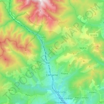
Nom : Carte topographique Comarnic, altitude, relief.

Lieu : Comarnic, Prahova, Romania (45.21566 25.53265 45.32260 25.70355)

Altitude moyenne : 885 m

Altitude minimum : 504 m

Altitude maximum : 1 642 m

Autres cartes topographiques

Cliquez sur une carte pour visualiser sa topographie, son altitude et son relief.

Barajul Paltinu

Romania > Prahova > Brebu

Altitude moyenne : 741 m

Țintea

Romania > Prahova > Băicoi

Altitude moyenne : 279 m

Valea Unghiului

Romania > Prahova

Altitude moyenne : 371 m

Ogretin

Romania > Prahova

Altitude moyenne : 485 m

Merci de soutenir ce site ❤️
Faire un don
🎯 Votre prochain emploi est peut-être à un message près : emploichat.fr

Câmpina

Romania > Prahova

Altitude moyenne : 463 m

Omu

Romania > Prahova > Bușteni

Altitude moyenne : 2 202 m

Slon

Romania > Prahova

Altitude moyenne : 729 m

Zăganu

Romania > Prahova

Altitude moyenne : 1 474 m

Arva

Romania > Prahova

Altitude moyenne : 169 m

Omu

Romania > Prahova > Bușteni

Altitude moyenne : 2 202 m

Dâmbu

Romania > Prahova > Băicoi

Altitude moyenne : 300 m

Teșila

Romania > Prahova

Altitude moyenne : 882 m

Merci de soutenir ce site ❤️
Faire un don
🎯 Votre prochain emploi est peut-être à un message près : emploichat.fr

Schiulești

Romania > Prahova

Altitude moyenne : 628 m

Pietroșani

Romania > Prahova

Altitude moyenne : 103 m

Drajna de Sus

Romania > Prahova

Altitude moyenne : 467 m

Udrești

Romania > Prahova

Altitude moyenne : 283 m

Doftana

Romania > Prahova

Altitude moyenne : 450 m

Găgeni

Romania > Prahova

Altitude moyenne : 257 m

Trăisteni

Romania > Prahova

Altitude moyenne : 924 m

Ciucaș

Romania > Prahova

Altitude moyenne : 1 605 m

Merci de soutenir ce site ❤️
Faire un don
🎯 Votre prochain emploi est peut-être à un message près : emploichat.fr

Trăisteni

Romania > Prahova

Altitude moyenne : 907 m

Cătunu

Romania > Prahova

Altitude moyenne : 502 m

Românești

Romania > Prahova

Altitude moyenne : 116 m

Chiojdeanca

Romania > Prahova > Chiojdeanca

Altitude moyenne : 321 m

Măneciu

Romania > Prahova

Altitude moyenne : 1 058 m

Ciucaș

Romania > Prahova

Altitude moyenne : 1 605 m

Équipez-vous pour votre prochaine aventure :

📍Traces GPS randonnée - Suivi et analyse d’itinéraires GPS
🔥Réchauds de camping - Réchauds compacts pour cuisine outdoor
🎒Organisation du sac - Accessoires pour optimiser le rangement
📱Supports smartphone randonnée - Fixations pratiques pour navigation mobile
🎒Housse de Pluie Sac à Dos - Gardez vos affaires et cartes au sec par tous les temps

En tant que Partenaire Amazon, ce site perçoit une commission sur les achats éligibles sans surcoût pour vous.