
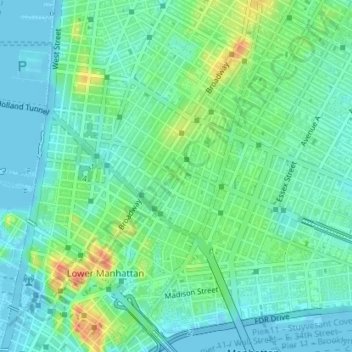
Carte topographique Little Italy
Carte interactive
Cliquez sur la carte pour afficher l’altitude.
À propos de cette carte
Nom : Carte topographique Little Italy, altitude, relief.
Altitude moyenne : 14 m
Altitude minimum : -7 m
Altitude maximum : 47 m
Autres cartes topographiques
Cliquez sur une carte pour visualiser sa topographie, son altitude et son relief.
New York County
United States > New York > New York
New York County, New York, United States
Altitude moyenne : 16 m
Manhattan Island
United States > New York > New York
Manhattan Island, New York, United States
Altitude moyenne : 17 m
Willets Point
United States > New York > New York
Willets Point, Queens, New York, 11359, United States
Altitude moyenne : 2 m
Sawmill Creek
United States > New York > New York
Sawmill Creek, Chelsea, Richmond County, New York, 10311, United States
Altitude moyenne : 3 m
Brooklyn
United States > New York > New York
Brooklyn, Kings County, New York, United States
Altitude moyenne : 9 m
Queens County
United States > New York > New York
Queens County, New York, United States
Altitude moyenne : 11 m
Staten Island
United States > New York > New York
Staten Island, New York, United States
Altitude moyenne : 11 m
The Bronx
United States > New York > New York
The Bronx, New York, United States
Altitude moyenne : 23 m
Bronx County
United States > New York > New York
Bronx County, The Bronx, New York, United States
Altitude moyenne : 21 m