
Carte topographique Bayerisch Eisenstein
Carte interactive
Cliquez sur la carte pour afficher l’altitude.
À propos de cette carte
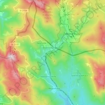
Nom : Carte topographique Bayerisch Eisenstein, altitude, relief.
Lieu : Bayerisch Eisenstein, Landkreis Regen, Bavaria, 94252, Germany (49.06051 13.13275 49.17362 13.23627)
Altitude moyenne : 919 m
Altitude minimum : 597 m
Altitude maximum : 1 445 m
Autres cartes topographiques
Cliquez sur une carte pour visualiser sa topographie, son altitude et son relief.
Großer Arber
Germany > Bavaria > Landkreis Regen > Bayerisch Eisenstein
Großer Arber, Bayerisch Eisenstein, Landkreis Regen, Bavaria, Germany
Altitude moyenne : 1 141 m
Bavarian Forest National Park
Germany > Bavaria > Landkreis Regen
Bavarian Forest National Park, Landkreis Regen, Bavaria, 94518, Germany
Altitude moyenne : 870 m