
Carte topographique Schlern
Carte interactive
Cliquez sur la carte pour afficher l’altitude.
À propos de cette carte
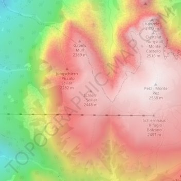
Nom : Carte topographique Schlern, altitude, relief.
Altitude moyenne : 2 033 m
Altitude minimum : 1 201 m
Altitude maximum : 2 553 m
Autres cartes topographiques
Cliquez sur une carte pour visualiser sa topographie, son altitude et son relief.
Völser Aicha
Italien > Trentino-Südtirol > Bozen > Völs am Schlern > Völser Aicha
Völser Aicha, Völs am Schlern, Salten-Schlern, Bozen, Trentino-Südtirol, 39053, Italien
Altitude moyenne : 831 m