
Carte topographique Serbie
Carte interactive
Cliquez sur la carte pour afficher l’altitude.
Serbie
Pour la période 1961-1990, la température moyenne annuelle a été de 10,9 °C jusqu’à une altitude de 300 m. Les régions situées entre 300 et 500 m ont connu une température moyenne de 10 °C et, au-dessus de 1 000 m, une température moyenne de 6 °C. Le mois de juillet est le mois le plus chaud de l’année, avec une température moyenne comprise entre 11 et 22 °C ; plus précisément, les régions situées à moins de 300 m d’altitude bénéficient d’une température moyenne comprise entre 20 et 22 °C, tout comme certains secteurs du sud de la Serbie situés à des altitudes entre 400 et 500 m. Au-dessus de 1 000 m d’altitude, les températures moyennes du mois de juillet sont comprises entre 11 et 16 °C. Les températures les plus basses de la période 1961-1990 ont été mesurées en janvier ; elles étaient comprises entre −35,6 °C (à Sjenica) et −21 °C (à Belgrade). Depuis le commencement des mesures, la température la plus élevée enregistrée en Serbie a été de 44,3 °C le 22 juillet 1939 à Kraljevo et la température la plus basse a été de −39,5 °C ; elle a été mesurée le 13 janvier 1985 à Karajukića Bunari, sur le plateau de Pešter, dans le district de Raška.
À propos de cette carte
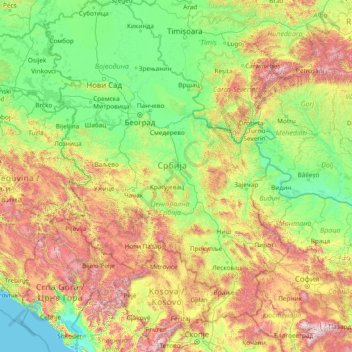
Nom : Carte topographique Serbie, altitude, relief.
Lieu : Serbie (41.85764 18.81499 46.19028 23.00631)
Altitude moyenne : 518 m
Altitude minimum : -3 m
Altitude maximum : 2 773 m
Autres cartes topographiques
Cliquez sur une carte pour visualiser sa topographie, son altitude et son relief.
Крушевица
Serbie > Serbie centrale > Јабланички управни округ > Општина Власотинце
Altitude moyenne : 704 m
Leskovac
Serbie > Serbie centrale > Јабланички управни округ
La ville est entourée par les monts Babička gora (1 038 m), Seličevica (903 m), Kruševica (910 m) et Suva planina à l'est, Radan (1 409 m) et Pasjača (971 m) à l'ouest, Kukavica et Čemernik (1 638 m) au sud ; au nord, elle est bordée par la dépression de Niš et, au sud, par les gorges de Grdelica,…
Altitude moyenne : 370 m
Kragujevac
Serbie > Serbie centrale > Шумадијски управни округ
La station météorologique de Kragujevac, située à 185 m d'altitude, enregistre des données depuis 1889 (coordonnées 44° 02′ N, 20° 56′ E).
Altitude moyenne : 320 m
Kruševac
Serbie > Serbie centrale > Расински управни округ
Kruševac est située au centre-est de la Serbie, dans la vallée éponyme de Kruševac, sur les bords de la Rasina et à proximité du confluent de cette rivière et de la Zapadna Morava ; la Ville et son territoire se trouvent entre les régions de Levač et de Temnić au nord, la région de la Župa, des…
Altitude moyenne : 274 m
Обреновац
Serbie > Serbie centrale > Ville de Belgrade > Градска општина Обреновац
Altitude moyenne : 89 m
Subotica
Serbie > Voïvodine > Севернобачки управни округ
La station météorologique de Subotica, qui se trouve à Palić, à quelques kilomètres de la ville, s'élève à une altitude de 102 m ; elle enregistre des données depuis 1936 (coordonnées 46° 06′ N, 19° 46′ E).
Altitude moyenne : 115 m
Шид
Serbie > Voïvodine > Сремски управни округ > Општина Шид
Šid est située dans la région de Syrmie, entre le Danube et les pentes de la Fruška gora au nord et la rivière de la Save au sud. La municipalité dont elle est le centre est la plus occidentale du district de Syrmie. L'altitude moyenne y est de 104 mètres.
Altitude moyenne : 105 m
Банатски Карловац
Serbie > Voïvodine > Јужнобанатски управни округ > Општина Алибунар
La station météorologique de Banatski Karlovac, située à 100 m d'altitude, enregistre des données depuis 1985 (coordonnées 45° 03′ N, 21° 02′ E).
Altitude moyenne : 108 m
Бобово
Serbie > Serbie centrale > Поморавски управни округ > Општина Свилајнац
Altitude moyenne : 179 m
Свилајнац
Serbie > Serbie centrale > Поморавски управни округ > Општина Свилајнац
Svilajnac est située sur les bords de la rivière Resava, à 100 km au sud-est de Belgrade. Le territoire de la municipalité, quant à lui, se trouve dans la région géographique de la basse Resava et s'étend sur 326 km2. Avec une altitude comprise entre 100 m et 389 m, la municipalité possèdent de…
Altitude moyenne : 115 m
Крњево
Serbie > Serbie centrale > Подунавски управни округ > Општина Велика Плана
Altitude moyenne : 143 m
Прањани
Serbie > Serbie centrale > Моравички управни округ > Општина Горњи Милановац
Altitude moyenne : 422 m
Zrenjanin
Serbie > Voïvodine > Средњобанатски управни округ > Zrenjanin
La station météorologique de Zrenjanin, située à 80 m d'altitude, enregistre des données depuis 1879 (coordonnées 45° 22′ N, 20° 25′ E).
Altitude moyenne : 80 m
Јаловик
Serbie > Serbie centrale > Мачвански управни округ > Општина Владимирци
Altitude moyenne : 139 m
Црни Врх
Serbie > Serbie centrale > Зајечарски управни округ > Општина Књажевац
Altitude moyenne : 974 m
Вршац
Serbie > Voïvodine > Јужнобанатски управни округ
Le territoire municipal est situé au sud-est de la plaine pannonienne et présente une relative variété sur le plan géomorphologique : on y trouve la dépression et la plaine alluviale de la rivière Karaš, des terrasses et des plateaux de lœss, ainsi que deux curiosités géographique : le désert de…
Altitude moyenne : 113 m
Лева Река
Serbie > Serbie centrale > Градска општина Врањска Бања > Лева Река
Altitude moyenne : 761 m
Златибор
Serbie > Serbie centrale > Златиборски управни округ > Општина Чајетина
Le point culminant du massif est le mont Tornik, qui s'élève à 1 496 m ; le mont Čigota, quant à lui, s'élève à 1 422 m. La partie méridionale de Zlatibor est constituée par le petit massif de la Murtenica, dont le point culminant est le mont Brijač, qui atteint 1 480 m d'altitude.
Altitude moyenne : 1 218 m
Сакар
Serbie > Serbie centrale > Мачвански управни округ > Општина Мали Зворник > Сакар
Altitude moyenne : 316 m
Доброселица
Serbie > Serbie centrale > Златиборски управни округ > Општина Чајетина
Altitude moyenne : 971 m
Миџор / Миджур
Serbie > Serbie centrale > Пиротски управни округ > Град Пирот
Altitude moyenne : 1 810 m
Сухи Дол
Serbie > Serbie centrale > Пчињски управни округ > Општина Сурдулица > Сухи Дол
Altitude moyenne : 921 m