
Carte topographique Khodjent
Carte interactive
Cliquez sur la carte pour afficher l’altitude.
À propos de cette carte
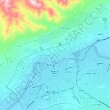
Nom : Carte topographique Khodjent, altitude, relief.
Lieu : Khodjent, Sughd, Tadjikistan (40.26239 69.56125 40.33168 69.67407)
Altitude moyenne : 465 m
Altitude minimum : 319 m
Altitude maximum : 1 229 m
Autres cartes topographiques
Cliquez sur une carte pour visualiser sa topographie, son altitude et son relief.
Нофин
Tadjikistan > Sughd > Ноҳияи Панҷакент
Нофин, Ноҳияи Панҷакент, Sughd, Tadjikistan
Altitude moyenne : 2 260 m
Ферганская долина
Ферганская долина, РБ19, Ноҳияи Ашт, Sughd, Tadjikistan
Altitude moyenne : 1 142 m
Навобод
Tadjikistan > Sughd > Ноҳияи Панҷакент
Навобод, Ноҳияи Панҷакент, Sughd, Tadjikistan
Altitude moyenne : 1 197 m
Истиқлол
Tadjikistan > Sughd > Ноҳияи Ғафуров > Истиқлол
Истиқлол, Ноҳияи Ғафуров, Sughd, 735731, Tadjikistan
Altitude moyenne : 1 298 m
Shimoliy Farg`ona Kanali
Shimoliy Farg`ona Kanali, Ноҳияи Ашт, Sughd, Tadjikistan
Altitude moyenne : 433 m