
Carte topographique Vermont
Carte interactive
Cliquez sur la carte pour afficher l’altitude.
À propos de cette carte
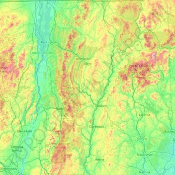
Nom : Carte topographique Vermont, altitude, relief.
Lieu : Vermont, United States (42.72696 -73.43774 45.01667 -71.46539)
Altitude moyenne : 348 m
Altitude minimum : -2 m
Altitude maximum : 1 893 m
The geography of the state is marked by the Green Mountains, which run north–south up the middle of the state, separating Lake Champlain and other valley terrain on the west from the Connecticut River Valley that defines much of its eastern border. Vermont's topography is remarked for being extremely rugged and a certain explanation for the state's consistently small population. A majority of its terrain is forested with hardwoods and conifers. The state's climate is characterized by warm and humid summers, and cold and snowy winters.
Autres cartes topographiques
Cliquez sur une carte pour visualiser sa topographie, son altitude et son relief.
Las Vegas
United States > Nevada > Clark County
Las Vegas, Clark County, Nevada, United States
Altitude moyenne : 756 m
York County
York County, Pennsylvania, United States
Altitude moyenne : 170 m
Cheatham County
Cheatham County, Middle Tennessee, Tennessee, United States
Altitude moyenne : 189 m
The Villages
United States > Florida > Sumter County
The Villages, Sumter County, Florida, United States
Altitude moyenne : 25 m
Shaver Lake
United States > California > Fresno County > Shaver Lake
Shaver Lake, Fresno County, California, 93664, United States
Altitude moyenne : 1 437 m
Little Saint James Island
United States > United States Virgin Islands > Saint Thomas - Saint John District
Little Saint James Island, Saint Thomas - Saint John District, United States Virgin Islands, United States
Altitude moyenne : 1 m
Three Rivers
United States > California > Tulare County
Three Rivers, Tulare County, California, United States
Altitude moyenne : 762 m
Three Rivers
United States > Texas > Live Oak County
Three Rivers, Live Oak County, Texas, 78071, United States
Altitude moyenne : 50 m
Nashville-Davidson
United States > Tennessee > Davidson County
Nashville-Davidson, Davidson County, Middle Tennessee, Tennessee, United States
Altitude moyenne : 184 m
Palmerville
United States > South Carolina > Berkeley County
Palmerville, Berkeley County, South Carolina, United States
Altitude moyenne : 8 m
Franklin County
Franklin County, Middle Tennessee, Tennessee, United States
Altitude moyenne : 349 m
Irrigosa
United States > California > Madera County
Irrigosa, Madera County, California, United States
Altitude moyenne : 85 m
Scotland
United States > Pennsylvania > Franklin County > Greene Township
Scotland, Greene Township, Franklin County, Pennsylvania, 17254, United States
Altitude moyenne : 220 m
Weston
United States > Maine > Aroostook County
Weston, Aroostook County, Maine, 04424, United States
Altitude moyenne : 150 m
Littleton
United States > Maine > Aroostook County
Littleton, Aroostook County, Maine, United States
Altitude moyenne : 140 m
Swanson
United States > Ohio > Harrison County
Swanson, Harrison County, Ohio, 43976, United States
Altitude moyenne : 342 m
Waverly
United States > Georgia > Richmond County > Augusta
Waverly, Augusta, Richmond County, Georgia, 30909, United States
Altitude moyenne : 96 m
Hawksbill
United States > Virginia > Madison County
Hawksbill, Madison County, Virginia, United States
Altitude moyenne : 993 m
Ashville
United States > Alabama > St. Clair County
Ashville, St. Clair County, Alabama, 35953, United States
Altitude moyenne : 190 m
Los Gatos
United States > California > Santa Clara County
Los Gatos, Santa Clara County, California, 95030, United States
Altitude moyenne : 209 m
Louisville
United States > Kentucky > Jefferson County
Louisville, Jefferson County, Kentucky, United States
Altitude moyenne : 188 m
Daniels
United States > West Virginia > Raleigh County
Daniels, Raleigh County, West Virginia, United States
Altitude moyenne : 774 m
Lima
United States > Montana > Beaverhead County
Lima, Beaverhead County, Montana, 59739, United States
Altitude moyenne : 1 910 m
Stanardsville
United States > Virginia > Greene County
Stanardsville, Greene County, Virginia, United States
Altitude moyenne : 205 m
Bartlesville
United States > Oklahoma > Washington County
Bartlesville, Washington County, Oklahoma, United States
Altitude moyenne : 231 m
Swansea
United States > South Carolina > Lexington County
Swansea, Lexington County, South Carolina, United States
Altitude moyenne : 117 m
Montrose
United States > Iowa > Lee County
Montrose, Lee County, Iowa, United States
Altitude moyenne : 179 m
Hillcrest
United States > Illinois > Ogle County
Hillcrest, Flagg Township, Ogle County, Illinois, United States
Altitude moyenne : 251 m
South Bend
United States > Indiana > Saint Joseph County
South Bend, Saint Joseph County, Indiana, United States
Altitude moyenne : 236 m
Dallas
United States > Texas > Dallas County
Dallas, Dallas County, Texas, United States
Altitude moyenne : 160 m
Baker
United States > California > Kern County > Boron
Baker, Boron, Kern County, California, United States
Altitude moyenne : 765 m
Prospect Park
United States > New York > New York
Prospect Park, Kings County, New York, United States
Altitude moyenne : 34 m
Atlanta
United States > Georgia > Fulton County
Atlanta, Fulton County, Georgia, United States
Altitude moyenne : 284 m
Village of Bronxville
United States > New York > Westchester County > Town of Eastchester
Village of Bronxville, Town of Eastchester, Westchester County, New York, 10708, United States
Altitude moyenne : 48 m
Grant Grove
United States > California > Fresno County
Grant Grove, Fresno County, California, United States
Altitude moyenne : 1 779 m
Daly City
United States > California > San Mateo County
Daly City, San Mateo County, California, United States
Altitude moyenne : 75 m
Mount Shasta
United States > California > Siskiyou County
Mount Shasta, Siskiyou County, California, United States
Altitude moyenne : 3 717 m
Chino
United States > California > San Bernardino County
Chino, San Bernardino County, California, United States
Altitude moyenne : 239 m
Scotts Valley
United States > California > Santa Cruz County
Scotts Valley, Santa Cruz County, California, 95066, United States
Altitude moyenne : 203 m
New Brunswick
United States > New Jersey > Middlesex County
New Brunswick, Middlesex County, New Jersey, United States
Altitude moyenne : 25 m
Manchester
United States > Vermont > Bennington County
Manchester, Bennington County, Vermont, United States
Altitude moyenne : 452 m
Mount Nebo
United States > Utah > Juab County
Mount Nebo, Juab County, Utah, United States
Altitude moyenne : 3 115 m
Elim
United States > Alaska > Unorganized Borough > Elim
Elim, Unorganized Borough, Alaska, 99739, United States
Altitude moyenne : 36 m
Grants Pass
United States > Oregon > Josephine County
Grants Pass, Josephine County, Oregon, United States
Altitude moyenne : 377 m