
Carte topographique Harburg (Schwaben)
Carte interactive
Cliquez sur la carte pour afficher l’altitude.
À propos de cette carte
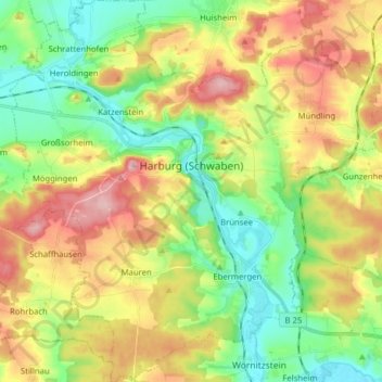
Nom : Carte topographique Harburg (Schwaben), altitude, relief.
Altitude moyenne : 473 m
Altitude minimum : 399 m
Altitude maximum : 577 m
Autres cartes topographiques
Cliquez sur une carte pour visualiser sa topographie, son altitude et son relief.
Ries
Germany > Bavaria > Landkreis Donau-Ries
Ries, Landkreis Donau-Ries, Bavaria, Germany
Altitude moyenne : 484 m
Rain
Germany > Bavaria > Landkreis Donau-Ries
Rain, Rain (Schwaben), Landkreis Donau-Ries, Bavaria, 86641, Germany
Altitude moyenne : 414 m
Hühnerberg
Germany > Bavaria > Landkreis Donau-Ries > Harburg (Schwaben)
Hühnerberg, Harburg (Schwaben), Landkreis Donau-Ries, Bavaria, 86655, Germany
Altitude moyenne : 436 m
Nördlingen
Germany > Bavaria > Landkreis Donau-Ries
Nördlingen, Landkreis Donau-Ries, Bavaria, Germany
Altitude moyenne : 453 m
Donauwörth
Germany > Bavaria > Landkreis Donau-Ries
Donauwörth, Landkreis Donau-Ries, Bavaria, 86609, Germany
Altitude moyenne : 443 m