
Carte topographique Saba
Carte interactive
Cliquez sur la carte pour afficher l’altitude.
À propos de cette carte
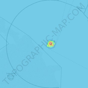
Nom : Carte topographique Saba, altitude, relief.
Lieu : Saba, Netherlands (17.41400 -63.46882 17.85000 -63.02603)
Altitude moyenne : 2 m
Altitude minimum : 0 m
Altitude maximum : 834 m
There is an 8.6 hectares (21 acres) cloud forest located at and above 825 metres (2,707 ft) on top of the mountain referred to as the "Elfin Forest Reserve" because of its high altitude mist and mossy appearance. The most dominant tree in the cloud forest is the Mountain Mahogany (Freziera undulate), although hurricanes over the years have destroyed a large number of the mature trees. Despite the name, the mountain mahogany is not related to other mahogany species; although one species of true mahogany tree is found on the island at lower levels, the small-leaved mahogany (Swietenia mahagoni). In the underbrush of the mahogany trees, the Sierran palm (Prestoea montana) and tree ferns dominate, with a large variety of epiphytes and Orchids growing on the trunks and branches of all the trees. Wild raspberries and plantain trees can also be found growing on most of the mountain. All seven of the Lesser Antilles Endemic Bird Area restricted-range birds occur in the Elfin Forest Reserve.
Autres cartes topographiques
Cliquez sur une carte pour visualiser sa topographie, son altitude et son relief.
Oostbeer
Netherlands > Zeeland > Philippine
Oostbeer, Philippine, Terneuzen, Zeeland, Netherlands
Altitude moyenne : 1 m
Rottumerplaat
Netherlands > Groningen > Warffum
Rottumerplaat, Warffum, Het Hogeland, Groningen, Netherlands
Altitude moyenne : 0 m
Rottumeroog
Netherlands > Groningen > Warffum
Rottumeroog, Warffum, Het Hogeland, Groningen, Netherlands
Altitude moyenne : 0 m
Wijnbergen
Netherlands > Gelderland > Doetinchem
Wijnbergen, Doetinchem, Gelderland, Netherlands, 7007 CA, Netherlands
Altitude moyenne : 15 m
's-Hertogenbosch
's-Hertogenbosch, North Brabant, Netherlands
Altitude moyenne : 4 m
Capelle aan den IJssel
Capelle aan den IJssel, South Holland, Netherlands
Altitude moyenne : -1 m
Capelle aan den IJssel
Netherlands > South Holland > Capelle aan den IJssel
Capelle aan den IJssel, Rotterdam, South Holland, Netherlands
Altitude moyenne : -1 m
Zeeuws-Vlaanderen
Netherlands > Zeeland > Terneuzen
Zeeuws-Vlaanderen, Terneuzen, Zeeland, Netherlands, 4542RZ, Netherlands
Altitude moyenne : 0 m
Zaanstad
Netherlands > North Holland > Zaanstad
Zaanstad, North Holland, Netherlands
Altitude moyenne : 0 m
Doetinchem
Netherlands > Gelderland > Doetinchem
Doetinchem, Gelderland, Netherlands
Altitude moyenne : 17 m
Het Hogeland
Netherlands > Groningen > Het Hogeland
Het Hogeland, Groningen, Netherlands
Altitude moyenne : 0 m
Gooise Meren
Netherlands > North Holland > Gooise Meren
Gooise Meren, North Holland, Netherlands
Altitude moyenne : 0 m
Rijswijk
Netherlands > South Holland > Rijswijk
Rijswijk, South Holland, Netherlands
Altitude moyenne : 2 m
Veldhoven
Netherlands > North Brabant > Veldhoven
Veldhoven, North Brabant, Netherlands
Altitude moyenne : 23 m
Mill
Netherlands > North Brabant > Mill en Sint Hubert
Mill, Mill en Sint Hubert, North Brabant, Netherlands
Altitude moyenne : 14 m
Velserbroek
Netherlands > North Holland > Velsen
Velserbroek, Velsen, North Holland, Netherlands
Altitude moyenne : 3 m
Park van Luna
Netherlands > North Holland > Heerhugowaard
Park van Luna, Stad van de Zon, Heerhugowaard, North Holland, Netherlands
Altitude moyenne : -2 m
Eindhoven
Netherlands > North Brabant > Eindhoven
Eindhoven, North Brabant, Netherlands
Altitude moyenne : 20 m
Zoetermeer
Netherlands > South Holland > Zoetermeer
Zoetermeer, South Holland, Netherlands
Altitude moyenne : -3 m
Horst aan de Maas
Horst aan de Maas, Limburg, Netherlands
Altitude moyenne : 27 m
Heerhugowaard
Netherlands > North Holland > Heerhugowaard
Heerhugowaard, North Holland, Netherlands
Altitude moyenne : -1 m