
Carte topographique Kasane
Carte interactive
Cliquez sur la carte pour afficher l’altitude.
À propos de cette carte
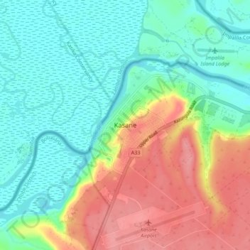
Nom : Carte topographique Kasane, altitude, relief.
Lieu : Kasane, Chobe District, Botswana (-17.83924 25.11655 -17.75924 25.19655)
Altitude moyenne : 951 m
Altitude minimum : 920 m
Altitude maximum : 1 004 m
Autres cartes topographiques
Cliquez sur une carte pour visualiser sa topographie, son altitude et son relief.
Chobe National Park
Chobe National Park, Chobe District, Botswana
Altitude moyenne : 964 m
Pandamatenga
Pandamatenga, Chobe District, Botswana
Altitude moyenne : 1 074 m