
Carte topographique Chobe National Park
Carte interactive
Cliquez sur la carte pour afficher l’altitude.
À propos de cette carte
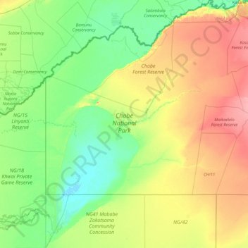
Nom : Carte topographique Chobe National Park, altitude, relief.
Lieu : Chobe National Park, Chobe District, Botswana (-19.33369 23.88217 -17.78777 25.18473)
Altitude moyenne : 964 m
Altitude minimum : 918 m
Altitude maximum : 1 094 m
Autres cartes topographiques
Cliquez sur une carte pour visualiser sa topographie, son altitude et son relief.