Géolocaliser

Carte topographique Chunya

Carte interactive

Cliquez sur la carte pour afficher l’altitude.

À propos de cette carte

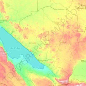
Nom : Carte topographique Chunya, altitude, relief.

Lieu : Chunya, Mbeya, Southern Highlands Zone, Tanzanie (-8.75505 31.97183 -6.90577 34.23427)

Altitude moyenne : 1 249 m

Altitude minimum : 795 m

Altitude maximum : 2 665 m

Autres cartes topographiques

Cliquez sur une carte pour visualiser sa topographie, son altitude et son relief.

Lukasi

Tanzanie > Mbeya

Lukasi, Busokelo, Mbeya, Southern Highlands Zone, Tanzanie

Altitude moyenne : 1 084 m

Rungwe

Tanzanie > Mbeya

Rungwe, Mbeya, Southern Highlands Zone, Tanzanie

Altitude moyenne : 2 636 m

Rungwe

Tanzanie > Mbeya

Rungwe, Mbeya, Southern Highlands Zone, Tanzanie

Altitude moyenne : 1 590 m

Kieyo

Tanzanie > Mbeya

Kieyo, Rungwe, Mbeya, Southern Highlands Zone, Tanzanie

Altitude moyenne : 1 974 m