
Carte topographique Mangan
Carte interactive
Cliquez sur la carte pour afficher l’altitude.
À propos de cette carte
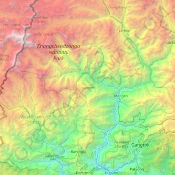
Nom : Carte topographique Mangan, altitude, relief.
Lieu : Mangan, North Sikkim District, Sikkim, India (27.37542 88.11250 27.68599 88.80824)
Altitude moyenne : 3 312 m
Altitude minimum : 373 m
Altitude maximum : 8 521 m
Autres cartes topographiques
Cliquez sur une carte pour visualiser sa topographie, son altitude et son relief.
South Lhonak Glacier
India > Sikkim > Chungthang
South Lhonak Glacier, Chungthang, Mangan District, Sikkim, India
Altitude moyenne : 5 830 m
Goecha La Lake
Goecha La Lake, Mangan, Mangan District, Sikkim, India
Altitude moyenne : 4 953 m
Pakyong
India > Sikkim > Pakyong subdivision
Pakyong, Pakyong subdivision, Pakyong District, Sikkim, 737106, India
Altitude moyenne : 1 235 m
Chungthang
Chungthang, North Sikkim District, Sikkim, 737120, India
Altitude moyenne : 4 598 m
Lachung Chu
India > Sikkim > Chungthang > Lachung
Lachung Chu, Lachung, Chungthang, North Sikkim District, Sikkim, India
Altitude moyenne : 4 332 m
North District
North District, North Sikkim District, Sikkim, India
Altitude moyenne : 3 760 m
Lower Sichey
Lower Sichey, Gangtok, East Sikkim District, Sikkim, India
Altitude moyenne : 1 352 m
West District
India > Sikkim > West District
West District, West Sikkim District, Sikkim, 737111, India
Altitude moyenne : 2 636 m
East District
India > Sikkim > East District
East District, East Sikkim District, Sikkim, India
Altitude moyenne : 2 740 m
Western Sikkim Subsection
Western Sikkim Subsection, North District, North Sikkim District, Sikkim, India
Altitude moyenne : 3 898 m
Lachung
India > Sikkim > Chungthang
Lachung, Chungthang, Mangan District, Sikkim, India
Altitude moyenne : 3 617 m
Upper Sichey
Upper Sichey, Gangtok, East Sikkim District, Sikkim, India
Altitude moyenne : 1 459 m
Lower M G Marg
Lower M G Marg, Gangtok, East Sikkim District, Sikkim, 737101, India
Altitude moyenne : 1 348 m
Teesta River
Teesta River, Namchi, South Sikkim District, Sikkim, 737132, India
Altitude moyenne : 1 113 m
Pegong
India > Sikkim > Chungthang
Pegong, Chungthang, North Sikkim District, Sikkim, India
Altitude moyenne : 1 950 m
Gurudongmar
India > Sikkim > Chungthang
Gurudongmar, Chungthang, North Sikkim District, Sikkim, India
Altitude moyenne : 5 232 m
South District
India > Sikkim > South District
South District, South Sikkim District, Sikkim, 737139, India
Altitude moyenne : 2 687 m
Zemu Glacier
Zemu Glacier, North District, North Sikkim District, Sikkim, India
Altitude moyenne : 5 499 m
Khecheopalri Lake
Khecheopalri Lake, MDR, Yuksom, West District, West Sikkim District, Sikkim, 737113, India
Altitude moyenne : 1 798 m
Tso Lhamo Lake
Tso Lhamo Lake, North District, North Sikkim District, Sikkim, India
Altitude moyenne : 5 146 m