
Carte topographique Singtam
Carte interactive
Cliquez sur la carte pour afficher l’altitude.
À propos de cette carte
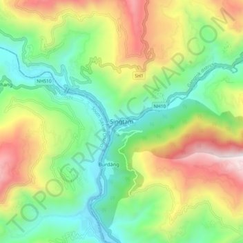
Nom : Carte topographique Singtam, altitude, relief.
Lieu : Singtam, Gangtok district, Sikkim, 737134, India (27.19200 88.45708 27.27200 88.53708)
Altitude moyenne : 894 m
Altitude minimum : 302 m
Altitude maximum : 1 889 m
Singtam is located at 27°09′N 88°23′E / 27.15°N 88.38°E / 27.15; 88.38. It has an average elevation of 1396 feet. As the town lies on the bank of two rivers River Teesta and Ranikhola, so during Monsoon especially from June to September the volume of both the river increases heavily, as a result destruction is caused on the low lying areas of the town especially at Adarsh gaon and Jublee line part of the town.
Autres cartes topographiques
Cliquez sur une carte pour visualiser sa topographie, son altitude et son relief.
South Lhonak Glacier
India > Sikkim > Chungthang
South Lhonak Glacier, Chungthang, Mangan District, Sikkim, India
Altitude moyenne : 5 830 m
Goecha La Lake
Goecha La Lake, Mangan, Mangan District, Sikkim, India
Altitude moyenne : 4 953 m
Pakyong
India > Sikkim > Pakyong subdivision
Pakyong, Pakyong subdivision, Pakyong District, Sikkim, 737106, India
Altitude moyenne : 1 235 m
Chungthang
Chungthang, North Sikkim District, Sikkim, 737120, India
Altitude moyenne : 4 598 m
Lachung Chu
India > Sikkim > Chungthang > Lachung
Lachung Chu, Lachung, Chungthang, North Sikkim District, Sikkim, India
Altitude moyenne : 4 332 m
North District
North District, North Sikkim District, Sikkim, India
Altitude moyenne : 3 760 m
Lower Sichey
Lower Sichey, Gangtok, East Sikkim District, Sikkim, India
Altitude moyenne : 1 352 m
West District
India > Sikkim > West District
West District, West Sikkim District, Sikkim, 737111, India
Altitude moyenne : 2 636 m
East District
India > Sikkim > East District
East District, East Sikkim District, Sikkim, India
Altitude moyenne : 2 740 m
Western Sikkim Subsection
Western Sikkim Subsection, North District, North Sikkim District, Sikkim, India
Altitude moyenne : 3 898 m
Lachung
India > Sikkim > Chungthang
Lachung, Chungthang, Mangan District, Sikkim, India
Altitude moyenne : 3 617 m
Upper Sichey
Upper Sichey, Gangtok, East Sikkim District, Sikkim, India
Altitude moyenne : 1 459 m
Lower M G Marg
Lower M G Marg, Gangtok, East Sikkim District, Sikkim, 737101, India
Altitude moyenne : 1 348 m
Teesta River
Teesta River, Namchi, South Sikkim District, Sikkim, 737132, India
Altitude moyenne : 1 113 m
Pegong
India > Sikkim > Chungthang
Pegong, Chungthang, North Sikkim District, Sikkim, India
Altitude moyenne : 1 950 m
Gurudongmar
India > Sikkim > Chungthang
Gurudongmar, Chungthang, North Sikkim District, Sikkim, India
Altitude moyenne : 5 232 m
South District
India > Sikkim > South District
South District, South Sikkim District, Sikkim, 737139, India
Altitude moyenne : 2 687 m
Zemu Glacier
Zemu Glacier, North District, North Sikkim District, Sikkim, India
Altitude moyenne : 5 499 m
Khecheopalri Lake
Khecheopalri Lake, MDR, Yuksom, West District, West Sikkim District, Sikkim, 737113, India
Altitude moyenne : 1 798 m
Tso Lhamo Lake
Tso Lhamo Lake, North District, North Sikkim District, Sikkim, India
Altitude moyenne : 5 146 m