
Carte topographique Zhejiang
Carte interactive
Cliquez sur la carte pour afficher l’altitude.
À propos de cette carte
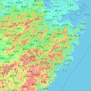
Nom : Carte topographique Zhejiang, altitude, relief.
Lieu : Zhejiang, China (26.85910 118.02241 31.18258 123.39362)
Altitude moyenne : 223 m
Altitude minimum : -2 m
Altitude maximum : 2 037 m
Zhejiang consists mostly of hills, which account for about 70% of its total area, with higher altitudes towards the south and the west. Zhejiang also has a longer coastline than any other mainland province of China. The Qiantang River runs through the province, from which it derives its name. Included in the province are three thousand islands, the most in China. The capital Hangzhou marks the end of the Grand Canal and lies on Hangzhou Bay on the north of Zhejiang, which separates Shanghai and Ningbo. The bay contains many small islands collectively called the Zhoushan Islands.
Autres cartes topographiques
Cliquez sur une carte pour visualiser sa topographie, son altitude et son relief.
Xingtan
China > Guangdong Province > Shunde District
Xingtan, Shunde District, Foshan, Guangdong Province, China
Altitude moyenne : 4 m
Baiyu
China > Sichuan > Baiyü County > Jianshe
Baiyu, Jianshe, Baiyü County, Kardze, Sichuan, 627100, China
Altitude moyenne : 3 959 m
Gaozhou City
China > Guangdong Province > Maoming City
Gaozhou City, Maoming City, Guangdong Province, 525200, China
Altitude moyenne : 187 m
卡瓦格博观景台
China > Tibet > Zogang County > Pütog
卡瓦格博观景台, 甲应路, Pütog, Zogang County, Chamdo City, Nyingchi Prefecture, Tibet, China
Altitude moyenne : 4 323 m
Tekes
China > Xinjiang > Tekes County
Tekes, Tekes County, Ili, Xinjiang, China
Altitude moyenne : 1 587 m
Linkou County
Linkou County, Mudanjiang City, Heilongjiang, China
Altitude moyenne : 432 m
Chini
China > Guangdong Province > Huadu District
Chini, Huadu District, Guangzhou City, Guangdong Province, China
Altitude moyenne : 30 m
Macau
China > Macau > São Lourenço
Macau, São Lourenço, Municipality of Macau, Macau, 519020, China
Altitude moyenne : 17 m
Chengguan District
Chengguan District, Lhasa, Tibet, 850000, China
Altitude moyenne : 4 325 m
Nanguan District
China > Jilin > Changchun City
Nanguan District, Changchun City, Jilin, 130000, China
Altitude moyenne : 241 m
Kashgar Prefecture
China > Xinjiang > Kashgar City
Kashgar Prefecture, Kashgar City, Kashgar Prefecture, Xinjiang, 844000, China
Altitude moyenne : 2 275 m
Danba
China > Sichuan > Danba County
Danba, Danba County, Kardze Tibetan Autonomous Prefecture, Sichuan, China
Altitude moyenne : 3 257 m
Chongchuan District
Chongchuan District, Nantong, Jiangsu, 226000, China
Altitude moyenne : 3 m
Guzai
China > Guangxi > Du'an Yao Autonomous County
Guzai, Du'an Yao Autonomous County, Hechi, Guangxi, China
Altitude moyenne : 152 m
Goujie
China > Yunnan > Yiliang County
Goujie, Yiliang County, Yunnan, China
Altitude moyenne : 1 810 m
Gaohong
China > Zhejiang > Lin'an District
Gaohong, Lin'an District, Hangzhou City, Zhejiang, China
Altitude moyenne : 282 m
Sha
China > Fujian > Fenggang Subdistrict
Sha, Fenggang Subdistrict, Shaxian District, Sanming City, Fujian, 365500, China
Altitude moyenne : 397 m
Keli
China > Fujian > Datian County
Keli, Datian County, Sanming City, Fujian, China
Altitude moyenne : 721 m
Northeast China
China > Heilongjiang > Harbin
Northeast China, Harbin, Heilongjiang, China
Altitude moyenne : 244 m
Shigatse
China > Tibet > Chengdong Subdistrict
Shigatse, Chengdong Subdistrict, Samzhubzê District, Shigatse Prefecture, Tibet, China
Altitude moyenne : 4 055 m
Qingshui River
China > Hebei > Zhangjiakou City > 闫家屯村
Qingshui River, 闫家屯村, Zhangjiakou City, Hebei, 075000, China
Altitude moyenne : 781 m