
Faire un don
Équipez-vous pour votre prochaine aventure :
En tant que Partenaire Amazon, ce site perçoit une commission sur les achats éligibles sans surcoût pour vous.
Carte topographique Nevado de Toluca
Cliquez sur la carte pour afficher l’altitude.
Faire un don
Équipez-vous pour votre prochaine aventure :
En tant que Partenaire Amazon, ce site perçoit une commission sur les achats éligibles sans surcoût pour vous.
À propos de cette carte
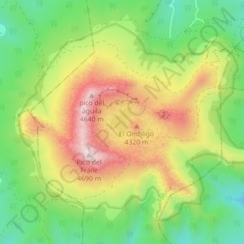
Nom : Carte topographique Nevado de Toluca, altitude, relief.
Lieu : Nevado de Toluca, Tenango del Valle, State of Mexico, Mexico (19.08614 -99.78529 19.13295 -99.72410)
Altitude moyenne : 4 037 m
Altitude minimum : 3 611 m
Altitude maximum : 4 659 m
Faire un don
Équipez-vous pour votre prochaine aventure :
En tant que Partenaire Amazon, ce site perçoit une commission sur les achats éligibles sans surcoût pour vous.
Autres cartes topographiques
Cliquez sur une carte pour visualiser sa topographie, son altitude et son relief.
Faire un don
Équipez-vous pour votre prochaine aventure :
En tant que Partenaire Amazon, ce site perçoit une commission sur les achats éligibles sans surcoût pour vous.
Temoaya
The climate is temperate and relatively humid with rains mostly in the summer. Average temperature is 13.4C, ranging between 9 and 35.5C. It is one of the coldest municipalities in the Toluca Valley due to its altitude. Frosts can occur between October and April and morning fog is not uncommon the rest of the…
Altitude moyenne : 2 790 m
Faire un don
Équipez-vous pour votre prochaine aventure :
En tant que Partenaire Amazon, ce site perçoit une commission sur les achats éligibles sans surcoût pour vous.
Faire un don
Équipez-vous pour votre prochaine aventure :
En tant que Partenaire Amazon, ce site perçoit une commission sur les achats éligibles sans surcoût pour vous.
Malinalco
As municipal seat, the town of Malinalco is the governing authority over 54 other named communities, which covers an area of 186.28 km2. The municipality, which shares its name with the seat, has a population of 22,970 of which only 6,523 live in the town of Malinalco. It has an average elevation of 1750…
Altitude moyenne : 1 871 m
Barrio el Toril Ejido la Soledad
Mexico > State of Mexico > San José del Rincón > San Isidro la Trinidad
Altitude moyenne : 2 701 m
Faire un don
Équipez-vous pour votre prochaine aventure :
En tant que Partenaire Amazon, ce site perçoit une commission sur les achats éligibles sans surcoût pour vous.
Tenancingo
The seat of the municipality is the town of Tenancingo, surrounded by mountains and forest. The main elevation overlooking the town is the Cerro de las Tres Marías, topped by a giant white statue of Christ the King (Cristo Rey), built in 1985, designed by Hector Morret and visible from just about anywhere in…
Altitude moyenne : 2 053 m
Faire un don
Équipez-vous pour votre prochaine aventure :
En tant que Partenaire Amazon, ce site perçoit une commission sur les achats éligibles sans surcoût pour vous.
Faire un don
Équipez-vous pour votre prochaine aventure :
En tant que Partenaire Amazon, ce site perçoit une commission sur les achats éligibles sans surcoût pour vous.
Ixtapan del Oro
It covers a total surface area of 82.49 km2 on a plateau at an altitude of 1,640 meters. In the year 2005 census, it reported a population of 6,349. The economy is principally farming, concentrating on the production of corn, bean and fruit. It has a tourist attractive for its weather, has one waterfall El…
Altitude moyenne : 1 948 m
Tehuastepec (San José Tehuastepec)
Mexico > State of Mexico > Valle de Bravo
Altitude moyenne : 2 241 m
Toluca
Mexico > State of Mexico > Toluca
Toluca is located at 2600 meters above sea level, being the highest capital city in Mexico and North America, which makes it temperate throughout the year with average temperatures ranging between 6 and 25 degrees Celsius during spring and summer, and from −5 to 20 degrees Celsius in winter. Its climate is…
Altitude moyenne : 2 729 m
Faire un don
Équipez-vous pour votre prochaine aventure :
En tant que Partenaire Amazon, ce site perçoit une commission sur les achats éligibles sans surcoût pour vous.
Otumba
Approximately 15% of Otumba's territory is hilly and mountainous terrain, a further 40% is sloping or undulating land. The remaining 45% is level plains and valleys. Elevation above mean sea level ranges from 2,300 to 2,900 metres (7,546 to 9,514 ft).
Altitude moyenne : 2 514 m
Faire un don
Équipez-vous pour votre prochaine aventure :
En tant que Partenaire Amazon, ce site perçoit une commission sur les achats éligibles sans surcoût pour vous.
Ojo de Agua
Mexico > State of Mexico > Tecámac
Ojo de Agua is the largest colonia in the municipality of Tecámac in State of Mexico, Mexico. It is located in the northeastern part of the state, northeast of Mexico City and within the Greater Mexico City urban area. It had a population of 386,290 people in the 2020 census. Ojo de Agua is the largest…
Altitude moyenne : 2 297 m
Faire un don
Équipez-vous pour votre prochaine aventure :
En tant que Partenaire Amazon, ce site perçoit une commission sur les achats éligibles sans surcoût pour vous.
Popocatépetl
Mexico > State of Mexico > Atlautla
According to paleomagnetic studies, the volcano is about 730,000 years old. It is cone shaped with a diameter of 25 km (16 mi) at its base, with a peak elevation of 5,450 m (17,880 ft). The crater is elliptical with an orientation northeast-southwest. The walls of the crater vary from 600 to 840 m (1,970 to…
Altitude moyenne : 4 810 m
Faire un don
Équipez-vous pour votre prochaine aventure :
En tant que Partenaire Amazon, ce site perçoit une commission sur les achats éligibles sans surcoût pour vous.
Tejupilco
Tejupilco is a municipality in the State of Mexico, Mexico, located approximately 100 kilometres (62 mi) southwest of the state capital Toluca, along Federal Highway 134. Its municipal seat is Tejupilco de Hidalgo. The municipality has a total area of about 1,327 km2 (512 sq mi), with a contrasting topography…
Altitude moyenne : 1 673 m
Tlalmanalco
The municipality has a number of elevations, including Teyotl, a 4700 meters and Tlatlachelo at 3175 meters. The latter has some Toltec-era shrines at its peak.
Altitude moyenne : 3 039 m
Faire un don
Équipez-vous pour votre prochaine aventure :
En tant que Partenaire Amazon, ce site perçoit une commission sur les achats éligibles sans surcoût pour vous.
Zacazonapan
The municipality borders the edge of the Sierra Madre del Sur giving it an uneven landscape with elevations such as the Cerro(hill) de La Pila, Cerro Sombrero, and Cerro Pelón. However, to the north there are also notable cerros such as El Xomil, Peña Colorada, and Peñas del Fraile. The most important river…
Altitude moyenne : 1 418 m
Faire un don
Équipez-vous pour votre prochaine aventure :
En tant que Partenaire Amazon, ce site perçoit une commission sur les achats éligibles sans surcoût pour vous.
Tonatico
Tonatico has several nearby mountains, including La Cruz and Tapachichi. The largest is La Puerta at 1,685 meters of elevation. The Salto de Zumpantitlán waterfall is nearby, along with the Tenancingo, San Geronimo and Taplalla rivers.
Altitude moyenne : 1 617 m
Faire un don
Équipez-vous pour votre prochaine aventure :
En tant que Partenaire Amazon, ce site perçoit une commission sur les achats éligibles sans surcoût pour vous.
Faire un don
Équipez-vous pour votre prochaine aventure :
En tant que Partenaire Amazon, ce site perçoit une commission sur les achats éligibles sans surcoût pour vous.
Faire un don
Équipez-vous pour votre prochaine aventure :
En tant que Partenaire Amazon, ce site perçoit une commission sur les achats éligibles sans surcoût pour vous.
San Nicolás Tolentino
Mexico > State of Mexico > Valle de Bravo > Valle de Bravo
Altitude moyenne : 1 572 m
Tultepec
The area was first settled by the Chichimecas, followed by the Otomis in the seventh century. After the Spanish invasion, Tultepec was given to Alonso Ávila along with the current municipalities of Zumpango, Xaltocán, Huehuetoca, Coyotepec, Teoloyucan and others, as part of the Encomienda de Cuautitlán. The…
Altitude moyenne : 2 254 m
Faire un don
Équipez-vous pour votre prochaine aventure :
En tant que Partenaire Amazon, ce site perçoit une commission sur les achats éligibles sans surcoût pour vous.
Malinalco
As municipal seat, the town of Malinalco is the governing authority over 54 other named communities, which covers an area of 186.28km2. The municipality, which shares its name with the seat, has a population of 22,970 of which only 6,523 live in the town of Malinalco. It has an average elevation of 1750 meters…
Altitude moyenne : 1 871 m
Atlacomulco
The municipality has rugged terrain, filled with mountains and hills. It is located on the Trans-Mexican Volcanic Belt, in the Lakes and Volcanos of Anáhuac region. Principle elevations include Cerro Xitije, Cerro Atlacomulco, Cerro La Cruz and Cerro El Cielito. Its altitude varies from 2720 to 3030 meters…
Altitude moyenne : 2 665 m
Metepec
Metepec (Spanish: [meteˈpek] ) is a municipality in the State of Mexico in Mexico and is located directly to the east of the state capital, Toluca, at an altitude of 2,635 metres (8,645 ft) above sea level. The center of Mexico City lies some 50 km further to the east. The city of Metepec also form part of…
Altitude moyenne : 2 625 m
Faire un don
Équipez-vous pour votre prochaine aventure :
En tant que Partenaire Amazon, ce site perçoit une commission sur les achats éligibles sans surcoût pour vous.
Toluca
Mexico > State of Mexico > Toluca
Toluca is located at 2600 meters above sea level, being the highest capital city in Mexico and North America, which makes it temperate throughout the year with average temperatures ranging between 6 and 25 degrees Celsius during spring and summer, and from −5 to 20 degrees Celsius in winter. Its climate is…
Altitude moyenne : 2 729 m
Texcoco de Mora
Mexico > State of Mexico > Texcoco
Tescoco lies about 25 km east of the centre of Mexico City. Major elevations in the municipality include the Tlaloc Mountain (4,500 meters) the Tetzcutzinco, Moyotepec and Tecuachacho. Most elevations are named after the major community to be found on them. There are also a number of small canyons. Part of the…
Altitude moyenne : 2 448 m
Faire un don
Équipez-vous pour votre prochaine aventure :
En tant que Partenaire Amazon, ce site perçoit une commission sur les achats éligibles sans surcoût pour vous.
Lerma
The municipality's territory is irregular with rolling hills leading up to the Sierra de Las Cruces mountain range, which extend from north to south on the east side of the municipality. In this range, there are a number of steep valleys, such as Salazar. Most of the residents are found in the foothills of the…
Altitude moyenne : 2 788 m
Naucalpan de Juárez
The highest peaks are the Organo and La Malinche mountains at 3,650 metres (11,980 feet) above sea level. Other notable elevations include la Cantera, El Cedral, San Joselito, La Plantación and Peña del Rayo. The main rivers through the area include the Totolina, San Lorenzo and Los Remedios. Water supply…
Altitude moyenne : 2 366 m
Faire un don
Équipez-vous pour votre prochaine aventure :
En tant que Partenaire Amazon, ce site perçoit une commission sur les achats éligibles sans surcoût pour vous.
Malinalco
As municipal seat, the town of Malinalco is the governing authority over 54 other named communities, which covers an area of 186.28km2. The municipality, which shares its name with the seat, has a population of 22,970 of which only 6,523 live in the town of Malinalco. It has an average elevation of 1750 meters…
Altitude moyenne : 1 871 m
Nevado de Toluca
Mexico > State of Mexico > Toluca
Most of the other sites are found on the crater's walls and peaks. One of the sites is called Xicotepec which is at the top of a rocky dome known as the Cerro de Ombligo (Spanish for "the navel"). Principally green obsidian blades and multicolored ceramic has been found here. On the north side of the crater is…
Altitude moyenne : 4 280 m
Faire un don
Équipez-vous pour votre prochaine aventure :
En tant que Partenaire Amazon, ce site perçoit une commission sur les achats éligibles sans surcoût pour vous.
Calimaya
The land in the municipality is mostly flat, with the west side. The highest elevation is 4,578 meters above sea level, which is located on the slopes of the Nevada de Toluca. The lowest elevation is 2,600. In addition to the Nevado, another elevation is the Tepemaxalco Mountain, popularly known as the Cerro…
Altitude moyenne : 2 882 m
Toluca
Mexico > State of Mexico > Toluca
The Lerma River flows from Lake Almoloya del Río through the center of the municipality towards the west, flowing into Lake Chapala. From this point westward the river takes the name of Río Grande de Santiago. And it goes from this lake to the Pacific Ocean in the state of Nayarit. The river is about 1,180…
Altitude moyenne : 2 729 m
Valle de Bravo
Mexico > State of Mexico > Valle de Bravo
The municipality is surrounded by mountain ranges and other elevated areas covering about 50% of the total area and include the Sierra de Temascaltepec, Sierra de Tenayac, Sierra de Valle de Bravos as wells as the hills that roll around the mountain ranges. These elevations include a number of small volcanoes…
Altitude moyenne : 1 914 m
Faire un don
Équipez-vous pour votre prochaine aventure :
En tant que Partenaire Amazon, ce site perçoit une commission sur les achats éligibles sans surcoût pour vous.
Ciudad López Mateos
Mexico > State of Mexico > Atizapán de Zaragoza
Its main elevations are Biznaga Hill, Atlaco Hill La Condesa Hill and Grande Hill.
Altitude moyenne : 2 426 m
Faire un don
Équipez-vous pour votre prochaine aventure :
En tant que Partenaire Amazon, ce site perçoit une commission sur les achats éligibles sans surcoût pour vous.
Barrio la Cascada (Barrio del Varal)
Mexico > State of Mexico > Temascaltepec
Altitude moyenne : 1 872 m
Ojo de Agua
Mexico > State of Mexico > Tecámac
Ojo de Agua is the largest colonia in the municipality of Tecámac in State of Mexico, Mexico. It is located in the northeastern part of the state, northeast of Mexico City and within the Greater Mexico City urban area. It had a 2010 census population of 242,272 inhabitants, or 66.45 percent of its…
Altitude moyenne : 2 297 m
Faire un don
Équipez-vous pour votre prochaine aventure :
En tant que Partenaire Amazon, ce site perçoit une commission sur les achats éligibles sans surcoût pour vous.
Monarch Butterfly Biosphere Reserve
Mexico > State of Mexico > Villa de Allende
The reserve extends from the mountainous forests of eastern Michoacán to western Mexico State 100 km northwest of Mexico City. The reserve in Michoacán contains the highest elevations in the state, including peaks that reach 2,700 masl (metres above sea level). The climate is classified as being temperate…
Altitude moyenne : 2 461 m
Faire un don
Équipez-vous pour votre prochaine aventure :
En tant que Partenaire Amazon, ce site perçoit une commission sur les achats éligibles sans surcoût pour vous.
Tequixquiac
Mexico > State of Mexico > Tequixquiac
The municipal seat is located in a small, narrow valley, but most of the municipality is on a high mesa between the Valley of Mexico and the Mezquital Valley. The highest mountain in Tequixquiac is the Cerro Mesa Ahumada, with an elevation of 2,600 metres (8,500 ft) above sea level, on the border between the…
Altitude moyenne : 2 296 m
Faire un don
Équipez-vous pour votre prochaine aventure :
En tant que Partenaire Amazon, ce site perçoit une commission sur les achats éligibles sans surcoût pour vous.