
Carte topographique Carpathian Mountains
Carte interactive
Cliquez sur la carte pour afficher l’altitude.
À propos de cette carte
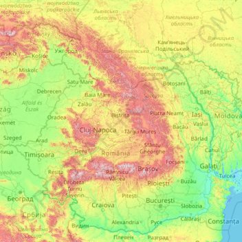
Nom : Carte topographique Carpathian Mountains, altitude, relief.
Lieu : Carpathian Mountains, Romania (43.39906 16.07849 50.06100 27.16369)
Altitude moyenne : 330 m
Altitude minimum : -3 m
Altitude maximum : 2 432 m
The northwestern Carpathians begin in Slovakia and southern Poland. They surround Transcarpathia and Transylvania in a large semicircle, sweeping towards the southeast, and end on the Danube near Orșova in Romania. The total length of the Carpathians is over 1,500 km (930 mi). The mountain chain's width varies between 12 and 500 km (7 and 311 mi). The highest altitudes of the Carpathians occur where they are widest. The system attains its greatest breadth in the Transylvanian plateau and in the southern Tatra Mountains group – the highest range, in which Gerlachovský štít in Slovakia is the highest peak, is 2,655 m (8,711 ft) above sea level. The Carpathians cover an area of 190,000 km2 (73,000 sq mi). After the Alps, they form the next-most extensive mountain system in Europe.
Autres cartes topographiques
Cliquez sur une carte pour visualiser sa topographie, son altitude et son relief.
Apuseni Mountains
Romania > Cluj > Valea Ierii
Apuseni Mountains, Valea Ierii, Cluj, Romania
Altitude moyenne : 1 615 m
Techirghiol
Techirghiol, Constanta Metropolitan Area, Constanța, 906100, Romania
Altitude moyenne : 23 m
Bâsca Chiojdului
Bâsca Chiojdului, Chiojdu, Buzău, 127171, Romania
Altitude moyenne : 732 m
Mârghia de Jos
Mârghia de Jos, Lunca Corbului, Argeș, 117441, Romania
Altitude moyenne : 265 m
Sita
Sita, Spermezeu, Bistrița-Năsăud, 427279, Romania
Altitude moyenne : 503 m
Lacul Mărul
Romania > Caraș-Severin > Poiana Mărului
Lacul Mărul, Poiana Mărului, Zăvoi, Caraș-Severin, 327439, Romania
Altitude moyenne : 827 m
Bâlea Lake
Romania > Sibiu > Cârțișoara
Bâlea Lake, Cârțișoara, Sibiu, Romania
Altitude moyenne : 2 080 m