
Carte topographique Buhweju
Carte interactive
Cliquez sur la carte pour afficher l’altitude.
À propos de cette carte
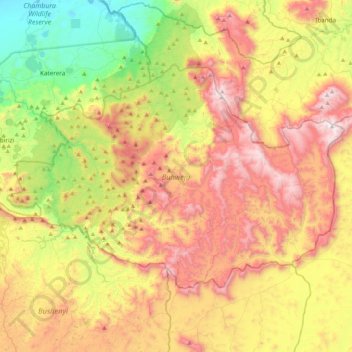
Nom : Carte topographique Buhweju, altitude, relief.
Lieu : Buhweju, Western Region, Uganda (-0.45505 30.09690 -0.18557 30.51874)
Altitude moyenne : 1 495 m
Altitude minimum : 920 m
Altitude maximum : 2 168 m
Autres cartes topographiques
Cliquez sur une carte pour visualiser sa topographie, son altitude et son relief.
Duka
Uganda > Bugisa sub-region > Mbale City
Duka, Mbale City, Bugisa sub-region, Eastern Region, Uganda
Altitude moyenne : 1 132 m
Ddewe Bwebajja A
Uganda > Central Region > Entebbe City
Ddewe Bwebajja A, Entebbe City, Central Region, Uganda
Altitude moyenne : 1 185 m
Education
Uganda > Bulambuli > Bugisa sub-region
Education, Bugisa sub-region, Bulambuli, Eastern Region, Uganda
Altitude moyenne : 1 088 m
Rubaga
Uganda > Central Region > Kampala
Rubaga, Kampala, Central Region, Uganda
Altitude moyenne : 1 187 m
Kitovu Nume
Uganda > Central Region > Masaka City
Kitovu Nume, Masaka City, Central Region, Uganda
Altitude moyenne : 1 240 m
Kigoowa I
Uganda > Central Region > Kampala
Kigoowa I, Kampala, Central Region, Uganda
Altitude moyenne : 1 194 m
Nakawa
Uganda > Central Region > Kampala
Nakawa, Kampala, Central Region, Uganda
Altitude moyenne : 1 178 m
Ruhaama Central
Ruhaama Central, Ntungamo, Western Region, Uganda
Altitude moyenne : 1 559 m
Kabazana B
Kabazana B, Kashojwa, Buganza, Isingiro, Western Region, Uganda
Altitude moyenne : 1 274 m
Senior Quarters 'a'
Senior Quarters 'a', Tororo, Eastern Region, Uganda
Altitude moyenne : 1 198 m