
Carte topographique Thyolo
Carte interactive
Cliquez sur la carte pour afficher l’altitude.
À propos de cette carte
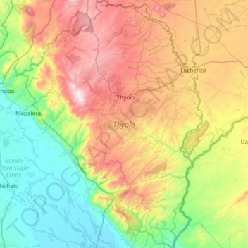
Nom : Carte topographique Thyolo, altitude, relief.
Lieu : Thyolo, Southern Region, Malawi, Malawi (-16.41078 34.90256 -15.84607 35.33082)
Altitude moyenne : 552 m
Altitude minimum : 49 m
Altitude maximum : 1 441 m
Autres cartes topographiques
Cliquez sur une carte pour visualiser sa topographie, son altitude et son relief.
Kasungu National Park
Kasungu National Park, Kasungu, Central Region, Malawi, Malawi
Altitude moyenne : 1 087 m
Nkhotakota
Malawi > Nkhotakota > Nkhotakota
Nkhotakota, Central Region, Malawi, Malawi
Altitude moyenne : 487 m
Uzumara Forest Reserve
Uzumara Forest Reserve, M1, Mojowa, Rumphi, Northern Region, Malawi
Altitude moyenne : 1 687 m
Lake Chilwa
Lake Chilwa, Zomba, Southern Region, Malawi
Altitude moyenne : 647 m