
Carte topographique Dedza
Carte interactive
Cliquez sur la carte pour afficher l’altitude.
À propos de cette carte
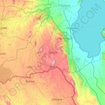
Nom : Carte topographique Dedza, altitude, relief.
Lieu : Dedza, Central Region, Malawi, Malawi (-14.61663 33.65006 -13.85837 34.74269)
Altitude moyenne : 971 m
Altitude minimum : 471 m
Altitude maximum : 2 142 m
The western part of the district is on the Central African Plateau at an altitude of 1 200 to 1,600 m. Higher mountain ranges separate this from land alongside Lake Malawi in the Rift Valley at 500 m. The landscape is a mixture of grassland with granite outcrops, natural woodland and commercial pine plantations on the mountains and some bamboo forest nearer the lake. The wet season is November to April with almost no rainfall at other times. The higher altitudes have moderate temperatures and can be cold in June and July.
Autres cartes topographiques
Cliquez sur une carte pour visualiser sa topographie, son altitude et son relief.
Kasungu National Park
Kasungu National Park, Kasungu, Central Region, Malawi, Malawi
Altitude moyenne : 1 087 m
Nkhotakota
Malawi > Nkhotakota > Nkhotakota
Nkhotakota, Central Region, Malawi, Malawi
Altitude moyenne : 487 m
Uzumara Forest Reserve
Uzumara Forest Reserve, M1, Mojowa, Rumphi, Northern Region, Malawi
Altitude moyenne : 1 687 m
Lake Chilwa
Lake Chilwa, Zomba, Southern Region, Malawi
Altitude moyenne : 647 m